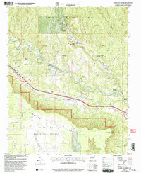
2002 Map of North San Ysidro
USGS Topo · Published 2003About this map
The Pecos River carves a path through this northern New Mexico landscape, anchoring the settlements of North San Ysidro and South San Ysidro. This 2002 revision shows a complex system of land management, featuring various tracts of the San Miguel Del Bado and the Los Trigos Grant Boundary. The terrain is defined by dramatic elevation shifts, from the heights of Glorieta Mesa to the rugged canyons of Los Alamitos Canyon and Apache Canyon.
Find a feature on this map
49 named features on this map. Tap any name to fly to it.
Don’t see what you’re looking for? This feature index may not catch every label — zoom into the map to look around manually.
Map Details
Editions of this 2002 North San Ysidro Map
This is the sole edition of this map. No revisions or reprints were ever made.
Other maps of this area

1889 · Las Vegas
USGS Topo · 1:125,000

1889 · Santa Fe
USGS Topo · 1:125,000

1890 · Bernal
USGS Topo · 1:125,000

1891 · Bernal
USGS Topo · 1:125,000

1891 · Las Vegas
USGS Topo · 1:125,000

1893 · Las Vegas
USGS Topo · 1:125,000

1894 · Santa Fe
USGS Topo · 1:125,000

1894 · Bernal
USGS Topo · 1:125,000

1894 · Lamy
USGS Topo · 1:125,000

1954 · Santa Fe
USGS Topo · 1:250,000