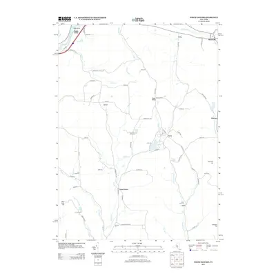
2013 Map of North Sanford
USGS Topo · Published 2013About this map
The Susquehanna River cuts through the northwest corner of this region, where the Middle Bridge connects local travel near the Balls Island riverbend. This rural landscape is defined by the headwaters of numerous creeks, including Oquaga Cr and Cold Spring Cr, which wind through a series of valleys and hills like Burnside Hill and Page Pond Hill. Small crossroads communities and hamlets such as North Sanford, East Afton, and the uniquely named China serve as focal points for the surrounding agricultural and forest lands. Local history and genealogy are anchored by several scattered burial grounds, including Beech Hill Cem, Melondy Hill Cem, and Arctic Cem. The presence of Baxters Tree Farm And Nursery and Camp Amahami near Page Pond highlights the area's continued reliance on the natural landscape for both industry and recreation.
Find a feature on this map
74 named features on this map. Tap any name to fly to it.
Don’t see what you’re looking for? This feature index may not catch every label — zoom into the map to look around manually.
Map Details
Editions of this 2013 North Sanford Map
This is the sole edition of this map. No revisions or reprints were ever made.
Other maps of this area

1902 · Coventry
USGS Topo · 1:62,500

1904 · Oxford
USGS Topo · 1:62,500

1905 · Nineveh
USGS Topo · 1:62,500

1915 · Unadilla
USGS Topo · 1:62,500

1918 · Unadilla
USGS Topo · 1:62,500

1924 · Deposit
USGS Topo · 1:62,500

1926 · Deposit
USGS Topo · 1:62,500

1943 · Sidney
USGS Topo · 1:24,000
1943 · Unadilla
USGS Topo · 1:24,000

1944 · Deposit
USGS Topo · 1:62,500