Old Maps of Chenango County, New York
Explore 197 old maps of Chenango County, spanning from 1902 to today. These high-resolution historic maps reveal how streets, neighborhoods, landmarks, and natural features evolved over time — perfect for genealogy, metal detecting, research, and local history exploration.
What you can do with these maps:
- See how Chenango County changed over time: Compare historical maps to modern-day views to trace roads, homesites, rail lines & more.
- View detailed metadata: Each map includes creators, publishers, year, scale, and archive source.
- Overlay maps with satellite & LiDAR: Visualize the past alongside modern tools to explore terrain & human change.
- Trusted historical sources: Maps sourced from the USGS, Library of Congress, and other archives.
- Access maps your way: View online, download high-res files, or order prints for personal or research use.
Start exploring old maps of Chenango County to uncover forgotten places, hidden landmarks, and the deep history beneath your feet.
Chenango County, NY maps
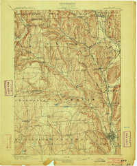
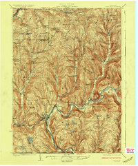
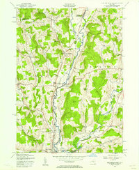
(197)- 1902 Map of Coventry
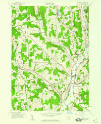
 1902 Coventry1902 Print · USGSChenango County at the start of the twentieth century was a landscape of hilltop farms and busy valley rail towns. Researchers can trace ancestral roots in Oxford, Coventry, and Brisben or locate family lands along Genegantslet Creek.2 unique versions available
 - 1903 Map of Norwich
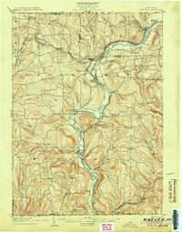
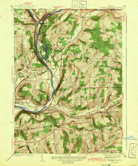
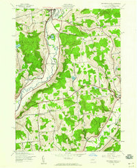
 1903 Norwich1903 Print · USGSChenango County at the dawn of the twentieth century was defined by the busy river valleys and rail lines connecting Norwich to Earlville. Researchers can trace the path of the N. Y. O. & W. R. R. through Sherburne Four Corners or locate family-named sites like Irelands Mills and Woods Corners.5 unique versions available
 - 1904 Map of Binghamton
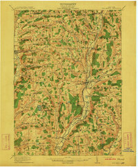
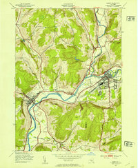
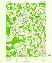
 1904 Binghamton1904 Print · USGSBinghamton at the turn of the century serves as the heart of a massive rail network where the Chenango and Susquehanna rivers meet. Researchers can trace the early layout of industrial Lestershire, the hill-station at Sanitaria Springs, and the diverse hamlets of New Ireland and Port Dickinson.9 unique versions available
 - 1904 Map of Greene
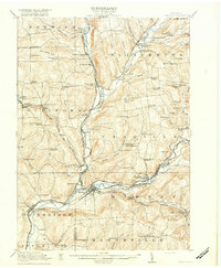
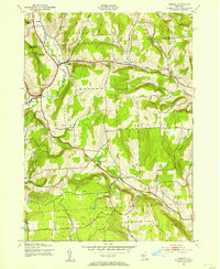
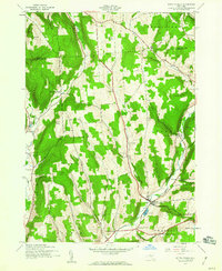
 1904 Greene1904 Print · USGSThe river valleys of Chenango and Broome counties come alive in this turn-of-the-century survey. You can trace the path of the Delaware Lackawanna and Western RR through Whitney Point or locate the early structures in Greene and Smithville Flats.6 unique versions available
 - 1904 Map of Oxford
 1904 Oxford1904 Print · USGSChenango County communities thrive along the river and rail corridors of the early twentieth century. Researchers can trace family homesteads near Oxford, locate Robinson Mill, or follow the routes of the New York Ontario and Western RR.5 unique versions available
 - 1904 Map of Pitcher
 1904 Pitcher1904 Print · USGSThe rural highlands of Central New York are documented here at the turn of the century, showing a landscape of upland hamlets and river-valley rail lines. Genealogists can trace early homesteads near Pitcher, Cincinnatus, and the remote heights of Taylor Center.5 unique versions available
 - 1905 Map of Nineveh
 1905 Nineveh1905 Print · USGSBroome County at the turn of the century shows a landscape dominated by the winding Susquehanna River and vital rail corridors. Genealogists can trace early homesteads and hamlets from Vallonia Springs to Center Village, alongside the path of the Delaware and Hudson railroad.6 unique versions available
 - 1910 Map of New Berlin, 1963 Print
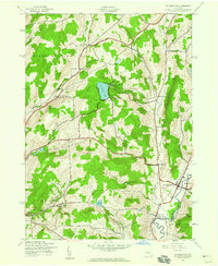
 1910 New Berlin1963 Print · USGSThe Unadilla and Chenango river valleys are seen here in the early twentieth century as established rail corridors and farming hubs. Researchers can trace the N Y O & W R R line through Holmesville or locate family sites like Kings Settlement and the Dimmick Hollow School.
 - 1912 Map of New Berlin
 1912 New Berlin1912 Print · USGSChenango County's river valleys and dairy uplands are meticulously captured in this pre-war survey of the New Berlin area. Genealogists can locate family-named landmarks and institutions like Columbus Hill Church, Kings Settlement, and the Dimmick Hollow School.4 unique versions available
 - 1915 Map of Unadilla, 1961 Print
 1915 Unadilla1961 Print · USGSThe river valleys of Chenango and Delaware counties are shown here during the height of the steam rail era. Researchers can trace the New York Ontario and Western lines through Sidney and Bainbridge, or locate the Friends Meeting House and dozens of rural schoolhouses.
 - 1918 Map of Unadilla
 1918 Unadilla1918 Print · USGSThe Susquehanna and Unadilla river valleys come alive during the years of World War I, showing a landscape of bustling rail junctions and riverside villages. Genealogists can trace family names at Lathams Corners or locate the Friends Meeting House and Sodom School.6 unique versions available
 - 1924 Map of Deposit, 1957 Print
 1924 Deposit1957 Print · USGSDelaware and Broome Counties are shown here in the mid-twenties, centered on the river-and-rail corridor near Deposit. Researchers can trace the original locations of communities like Cannonsville and Rock Royal, or find ancestral schoolhouses like Slow and Easy School.
 - 1926 Map of Deposit
 1926 Deposit1926 Print · USGSThe West Branch of the Delaware River winds through these hills in the mid-twenties, passing through the villages of Deposit and Cannonsville. Genealogists can trace dozens of rural school districts, including the Slow and Easy School, and find old homesteads near McClure Settlement.4 unique versions available
 - 1935 Map of Chenango Forks
 1935 Chenango Forks1935 Print · USGSThe river valleys and rail corridors of Broome County come alive in this mid-1930s survey of the Chenango Forks area. Genealogists can trace rural life through a network of local institutions like West Colesville Ch, Oak Hill Sch, and the C C C Camp.
 - 1942 Map of Chenango Forks
 1942 Chenango Forks1942 Print · USGSUpper Broome County in the years before the war shows a landscape shaped by river junctions and burgeoning state park development. Local historians can trace early school districts and railroad routes through Chenango Forks, Sanitaria Springs, and the CCC Camp at Chenango Valley State Park.3 unique versions available
 - 1943 Map of Sidney, 1953 Print
 1943 Sidney1953 Print · USGSThe Susquehanna and Unadilla rivers meet during the mid-forties, carving a landscape defined by industrial rail lines and valley settlements. Genealogists can trace family roots through Greenlawn Cem, the village of Bainbridge, and the junction at Sidney.3 unique versions available
 - 1943 Map of Otselic, 1954 Print
 1943 Otselic1954 Print · USGSChenango County hills and valleys are captured here during the 1940s, showing a landscape of upland farms and remote school districts. Genealogists can trace family footprints near Maple Grove Cem or through small crossroads like Stanbro and Bonney.3 unique versions available
 - 1943 Map of New Berlin North, 1957 Print
 1943 New Berlin North1957 Print · USGSChenango and Otsego counties meet along the river in the 1940s, showing a landscape of interconnected valley farms and upland hamlets. Genealogists can trace family sites like Lloyd Cem and Perkinsons Cem or follow the Unadilla Valley River rail line.4 unique versions available
 - 1943 Map of New Berlin South, 1960 Print
 1943 New Berlin South1960 Print · USGSOtsego and Chenango Counties are captured here in the early 1940s, showcasing a rural landscape of river valleys and upland hill farms. Researchers can trace the old school districts at Deming Sch or Wheeler Sch and locate local landmarks like Collier Bridge.3 unique versions available
 - 1943 Map of Gilbertsville, 1960 Print
 1943 Gilbertsville1960 Print · USGSOtsego County during the early 1940s reveals a rural landscape of crossroads settlements and small schoolhouses. Genealogists can trace family locations through numerous named landmarks like Heslops Corner, Brookside Cem, and Unadilla Center.2 unique versions available
 - 1943 Map of South Ostelic, 1960 Print
 1943 South Ostelic1960 Print · USGSChenango County was a landscape of high hills and river-fed hamlets during the early years of the Second World War. Genealogists can trace family footprints at Crumb Hill Cem, the Seventh Day Hollow Ch, and the isolated Mariposa crossroads.3 unique versions available
 - 1943 Map of Cincinnatus, 1960 Print
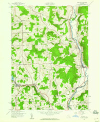
 1943 Cincinnatus1960 Print · USGSCortland County during the mid-1940s remained a landscape of tight-knit valley settlements and upland district schools. Genealogists can trace family roots through sites like Hawley Cem or follow the path of the Delaware Lackawanna and Western railroad.3 unique versions available
 - 1943 Map of Holmesville, 1960 Print
 1943 Holmesville1960 Print · USGSChenango County's eastern river valleys and upland settlements are captured here during the 1940s. Genealogists and local historians can trace the rural landscape between South New Berlin and Holmesville, locating small burial grounds like Bloom Cem and old landmarks like the Lookout Tower.4 unique versions available
 - 1943 Map of Norwich, 1960 Print
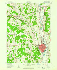 1943 Norwich1960 Print · USGSChenango County enters the mid-century as a hub of river-valley transport and upland farming, captured here just as the local rail network remained a fixture. Researchers can trace family plots at Packer-Mason Cem, locate the former County Home, or follow the New York Ontario and Western line through North Norwich.2 unique versions available
 - 1943 Map of Guilford, 1960 Print
 1943 Guilford1960 Print · USGSChenango County during the early 1940s reveals a landscape of river-valley industry and quiet upland hamlets. You can trace the New York Ontario and Western rail line as it serves riverside spots like Rockwells Mills and Mount Upton.3 unique versions available
Showing maps 1-25 of 197
Top cities of Chenango County
- Norwich historical maps
- Greene historical maps
- Sherburne historical maps
- Oxford historical maps
- Norwich historical maps
- Bainbridge historical maps
See more
Frequently asked questions
- What are the different types of historical maps available for Chenango County?
- What is the oldest map of Chenango County?
- Where can I purchase historical maps of Chenango County for my home or office?
- Where can I download high-res historical maps of Chenango County?
- Are there historical topographic maps available for Chenango County?
- Is there historical aerial imagery available for Chenango County?
- Where are historical maps of Chenango County sourced from?