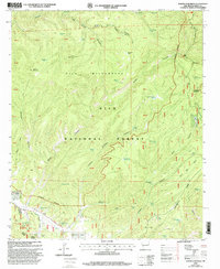
1999 Map of North Star Mesa
USGS Topo · Published 2002About this map
Loco Mountain and Middle Mountain dominate this high-desert territory within the Gila National Forest, a landscape defined by its network of water management features and steep canyon systems. The transition from the high peaks of the Gila Wilderness and Aldo Leopold Wilderness down toward Sapillo Creek reveals a remote cattle-ranching and resource-management economy. Numerous tanks and wells, such as Terry Well, Red Sap Well, and Turkey Cienega Tank, illustrate the critical importance of water distribution across this high terrain. The southern portion of the sheet shows the transition from the wilderness toward the small settlement at V-Cross Ranch and the open space of Gattons Park. The Continental Divide winds through the eastern side of the quadrangle, crossing Star Mesa and overlooking Terry Canyon, providing a detailed look at the hydrology of the American Southwest at the turn of the millennium.
Find a feature on this map
75 named features on this map. Tap any name to fly to it.
Don’t see what you’re looking for? This feature index may not catch every label — zoom into the map to look around manually.
Map Details
Editions of this 1999 North Star Mesa Map
This is the sole edition of this map. No revisions or reprints were ever made.
Other maps of this area

1909 · Silver City
USGS Topo · 1:125,000

1911 · Alum Mountain
USGS Topo · 1:125,000

1913 · Alum Mountain
USGS Topo · 1:125,000

1947 · Allie Canyon
USGS Topo · 1:24,000

1947 · Twin Sisters
USGS Topo · 1:24,000

1948 · Twin Sisters
USGS Topo · 1:24,000

1948 · Allie Canyon
USGS Topo · 1:24,000

1954 · Tularosa
USGS Topo · 1:250,000

1954 · Silver City
USGS Topo · 1:250,000

1954 · Clifton
USGS Topo · 1:250,000