
1965 Map of North Star
USGS Topo · Published 1966About this map
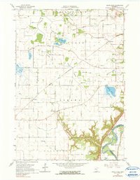
Lake Prairie and the surrounding townships of Oshawa and Belgrade are defined by an intricate network of drainage ditches and converted marshlands in the mid-1960s. The landscape is dotted with numerous dry basins such as Timber Lakebed and Goose Lakebed, reflecting a highly engineered agricultural environment. Small pockets of open water remain at Erickson Lake and Overson Lake, while the southeastern corner is dominated by the deeply carved valley of the Minnesota River.
Find a feature on this map
24 named features on this map. Tap any name to fly to it.
Don’t see what you’re looking for? This feature index may not catch every label — zoom into the map to look around manually.
Map Details
Editions of this 1965 North Star Map
2 editions found
Other maps of this area

1950 · Mankato East
USGS Topo · 1:62,500

1951 · Mankato East
USGS Topo · 1:62,500

1951 · Mankato West
USGS Topo · 1:62,500

1953 · Saint Paul
USGS Topo · 1:250,000

1953 · New Ulm
USGS Topo · 1:250,000

1957 · New Ulm
USGS Topo · 1:250,000

1958 · New Ulm
USGS Topo · 1:250,000

1959 · Saint Paul
USGS Topo · 1:250,000

1965 · Norseland
USGS Topo · 1:24,000

1965 · New Sweden
USGS Topo · 1:24,000