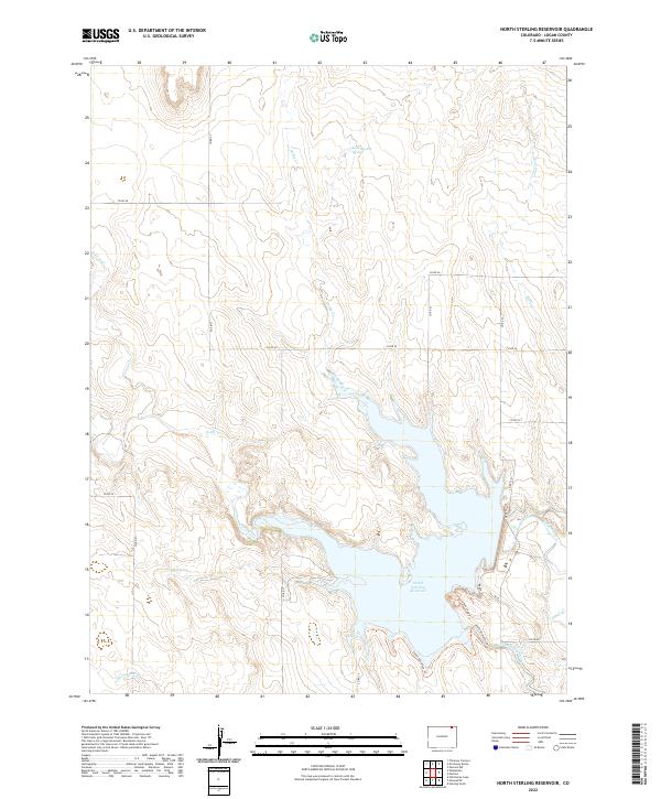
2022 Map of North Sterling Reservoir
USGS Topo · Published 2022About this map
North Sterling Reservoir dominates the lower half of this Logan County landscape, serving as a critical water management feature for the high plains of northeastern Colorado. This contemporary survey details the engineering of the Dam and the extensive North Sterling Canal which diverts water to the surrounding agricultural land. The terrain is defined by a network of seasonal drainages, including Darby Creek, Cedar Creek, and Beall Cr, which feed into the reservoir from the north. Historically significant water sources like Seventeenmile Spring and Blood Spring highlight the locations of essential prairie water points. A modern recreational infrastructure is visible along the shoreline through the Beach Trl, Overlook Loop Trl, and South Shoreline Trl, while a grid of county roads such as Co RD 54 and Co RD 25 provide access across the townships of t10n r54w and t9n r53w.
Find a feature on this map
32 named features on this map. Tap any name to fly to it.
Don’t see what you’re looking for? This feature index may not catch every label — zoom into the map to look around manually.
Map Details
Editions of this 2022 North Sterling Reservoir Map
This is the sole edition of this map. No revisions or reprints were ever made.
Other maps of this area

1951 · Sterling North
USGS Topo · 1:24,000

1951 · Wild Horse Lake
USGS Topo · 1:24,000

1951 · Atwood NE
USGS Topo · 1:24,000

1951 · Padroni NW
USGS Topo · 1:24,000

1952 · Padroni
USGS Topo · 1:24,000

1954 · Sterling
USGS Topo · 1:250,000

1958 · Sterling
USGS Topo · 1:250,000
1978 · Kirchnavy Butte
USGS Topo · 1:24,000
1978 · Chimney Canyons
USGS Topo · 1:24,000
1978 · North Sterling Reservoir
USGS Topo · 1:24,000