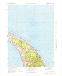
1972 Map of North Truro
USGS Topo · Published 1978About this map
Cape Cod National Seashore dominates the narrow outer arm of the peninsula in this early 1970s record, revealing a landscape defined by shifting sands and maritime history. The coastal terrain is marked by prominent ridges and depressions such as Kings Hollow and Great Hollow, while the iconic Highland Light (Cape Cod Light) stands watch over the Atlantic shore near a Coast Guard Sta. This era represents a period of transition, where established settlements like North Truro and Pond Village exist alongside the Cold War-era North Truro Air Force Station.
Find a feature on this map
41 named features on this map. Tap any name to fly to it.
Don’t see what you’re looking for? This feature index may not catch every label — zoom into the map to look around manually.
Map Details
Editions of this 1972 North Truro Map
3 editions found
Historical Maps of Truro Through Time
186 maps found

1886 Falmouth
Barnstable County, MA

1887 Provincetown
Barnstable County, MA

1887 Wellfleet
Barnstable County, MA

1887 Yarmouth
Barnstable County, MA

1888 Barnstable
Barnstable County, MA

1888 Chatham
Barnstable County, MA

1888 Falmouth
Barnstable County, MA

1889 Provincetown
Barnstable County, MA

1889 Wellfleet
Barnstable County, MA

1889 Yarmouth
Barnstable County, MA

1893 Barnstable
Barnstable County, MA

1893 Chatham
Barnstable County, MA

1893 Falmouth
Barnstable County, MA

1893 Wellfleet
Barnstable County, MA

1893 Yarmouth
Barnstable County, MA

1898 Provincetown
Barnstable County, MA

1915 Falmouth
Barnstable County, MA

1917 Chatham
Barnstable County, MA

1920 Falmouth
Barnstable County, MA

1936 Falmouth
Barnstable County, MA

1938 Sandwich
Barnstable County, MA

1939 Sandwich
Barnstable County, MA

1940 Sandwich
Barnstable County, MA

1941 Cotuit
Barnstable County, MA

1941 Falmouth
Barnstable County, MA

1942 Cape Cod Bay
Barnstable County, MA

1942 Chatham
Barnstable County, MA

1942 Hyannis
Barnstable County, MA

1942 Monomoy Point
Barnstable County, MA

1942 Nauset
Barnstable County, MA

1943 Chatham
Barnstable County, MA

1943 Cotuit
Barnstable County, MA

1943 Dennis
Barnstable County, MA

1943 Harwich
Barnstable County, MA

1943 Sandwich
Barnstable County, MA

1944 North Truro
Barnstable County, MA

1944 Orleans
Barnstable County, MA

1944 Provincetown
Barnstable County, MA

1944 Wellfleet
Barnstable County, MA

1946 Falmouth
Barnstable County, MA

1946 Orleans
Barnstable County, MA

1947 Chatham
Barnstable County, MA

1948 Falmouth
Barnstable County, MA

1949 Cotuit
Barnstable County, MA

1949 Dennis
Barnstable County, MA

1949 Falmouth
Barnstable County, MA

1949 Harwich
Barnstable County, MA

1949 Provincetown
Barnstable County, MA

1950 Hyannis
Barnstable County, MA

1953 Monomoy Point
Barnstable County, MA

1957 Falmouth
Barnstable County, MA

1957 Sandwich
Barnstable County, MA

1958 North Truro
Barnstable County, MA

1958 Provincetown
Barnstable County, MA

1958 Wellfleet
Barnstable County, MA

1961 Chatham
Barnstable County, MA

1961 Cotuit
Barnstable County, MA

1961 Dennis
Barnstable County, MA

1961 Harwich
Barnstable County, MA

1961 Hyannis
Barnstable County, MA

1962 Orleans
Barnstable County, MA

1964 Monomoy Point
Barnstable County, MA

1972 Falmouth
Barnstable County, MA

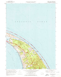
1972 North Truro
Barnstable County, MA

1972 Provincetown
Barnstable County, MA

1972 Sandwich
Barnstable County, MA

1972 Wellfleet
Barnstable County, MA

1974 Chatham
Barnstable County, MA

1974 Cotuit
Barnstable County, MA

1974 Dennis
Barnstable County, MA

1974 Harwich
Barnstable County, MA

1974 Hyannis
Barnstable County, MA

1974 Monomoy Point
Barnstable County, MA

1974 Orleans
Barnstable County, MA

1977 Chatham
Barnstable County, MA

1977 Cotuit
Barnstable County, MA

1977 Dennis
Barnstable County, MA

1977 Falmouth
Barnstable County, MA

1977 Harwich
Barnstable County, MA

1977 Hyannis
Barnstable County, MA

1977 Monomoy Point
Barnstable County, MA

1977 North Truro
Barnstable County, MA

1977 Orleans
Barnstable County, MA

1977 Provincetown
Barnstable County, MA

1977 Sandwich
Barnstable County, MA

1977 Wellfleet
Barnstable County, MA

1986 Chatham
Barnstable County, MA

1993 Chatham
Barnstable County, MA

2012 Chatham
Barnstable County, MA

2012 Cotuit
Barnstable County, MA

2012 Dennis
Barnstable County, MA

2012 Dennis OE N
Barnstable County, MA

2012 Falmouth
Barnstable County, MA

2012 Harwich
Barnstable County, MA

2012 Hyannis
Barnstable County, MA

2012 Hyannis OE S
Barnstable County, MA

2012 Monomoy Point
Barnstable County, MA

2012 Monomoy Point OE W
Barnstable County, MA

2012 North Truro
Barnstable County, MA

2012 Orleans
Barnstable County, MA

2012 Orleans OE W
Barnstable County, MA

2012 Provincetown
Barnstable County, MA

2012 Provincetown OE W
Barnstable County, MA

2012 Sandwich
Barnstable County, MA

2012 Sandwich OE N
Barnstable County, MA

2012 Wellfleet
Barnstable County, MA

2012 Wellfleet OE E
Barnstable County, MA

2015 Chatham
Barnstable County, MA

2015 Cotuit
Barnstable County, MA

2015 Dennis
Barnstable County, MA

2015 Dennis OE N
Barnstable County, MA

2015 Falmouth
Barnstable County, MA

2015 Harwich
Barnstable County, MA

2015 Hyannis
Barnstable County, MA

2015 Hyannis OE S
Barnstable County, MA

2015 Monomoy Point
Barnstable County, MA

2015 Monomoy Point OE W
Barnstable County, MA

2015 North Truro
Barnstable County, MA

2015 Orleans
Barnstable County, MA

2015 Orleans OE W
Barnstable County, MA

2015 Provincetown
Barnstable County, MA

2015 Provincetown OE W
Barnstable County, MA

2015 Sandwich
Barnstable County, MA

2015 Sandwich OE N
Barnstable County, MA

2015 Wellfleet
Barnstable County, MA

2015 Wellfleet OE E
Barnstable County, MA

2018 Chatham
Barnstable County, MA

2018 Cotuit
Barnstable County, MA

2018 Dennis
Barnstable County, MA

2018 Dennis OE N
Barnstable County, MA

2018 Falmouth
Barnstable County, MA

2018 Harwich
Barnstable County, MA

2018 Hyannis
Barnstable County, MA

2018 Hyannis OE S
Barnstable County, MA

2018 Monomoy Point
Barnstable County, MA

2018 Monomoy Point OE W
Barnstable County, MA

2018 North Truro
Barnstable County, MA

2018 Orleans
Barnstable County, MA

2018 Orleans OE W
Barnstable County, MA

2018 Provincetown
Barnstable County, MA

2018 Provincetown OE W
Barnstable County, MA

2018 Sandwich
Barnstable County, MA

2018 Sandwich OE N
Barnstable County, MA

2018 Wellfleet
Barnstable County, MA

2018 Wellfleet OE E
Barnstable County, MA

2021 Chatham
Barnstable County, MA

2021 Cotuit
Barnstable County, MA

2021 Dennis
Barnstable County, MA

2021 Dennis OE N
Barnstable County, MA

2021 Falmouth
Barnstable County, MA

2021 Harwich
Barnstable County, MA

2021 Hyannis
Barnstable County, MA

2021 Hyannis OE S
Barnstable County, MA

2021 Monomoy Point
Barnstable County, MA

2021 Monomoy Point OE W
Barnstable County, MA

2021 North Truro
Barnstable County, MA

2021 Orleans
Barnstable County, MA

2021 Orleans OE W
Barnstable County, MA

2021 Provincetown
Barnstable County, MA

2021 Provincetown OE W
Barnstable County, MA

2021 Sandwich
Barnstable County, MA

2021 Sandwich OE N
Barnstable County, MA

2021 Wellfleet
Barnstable County, MA

2021 Wellfleet OE E
Barnstable County, MA

2023 Cotuit
Barnstable County, MA

2023 Hyannis
Barnstable County, MA

2023 Orleans
Barnstable County, MA

2024 Chatham
Barnstable County, MA

2024 Cotuit
Barnstable County, MA

2024 Dennis
Barnstable County, MA

2024 Dennis OE N
Barnstable County, MA

2024 Falmouth
Barnstable County, MA

2024 Harwich
Barnstable County, MA

2024 Hyannis
Barnstable County, MA

2024 Hyannis OE S
Barnstable County, MA

2024 Monomoy Point
Barnstable County, MA

2024 Monomoy Point OE W
Barnstable County, MA

2024 North Truro
Barnstable County, MA

2024 Orleans
Barnstable County, MA

2024 Orleans OE W
Barnstable County, MA

2024 Provincetown
Barnstable County, MA

2024 Provincetown OE W
Barnstable County, MA

2024 Sandwich
Barnstable County, MA

2024 Sandwich OE N
Barnstable County, MA

2024 Wellfleet
Barnstable County, MA

2024 Wellfleet OE E
Barnstable County, MA