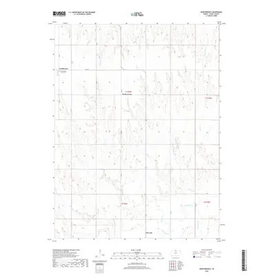
2018 Map of Northbranch
USGS Topo · Published 2018About this map
Burr Oak and the surrounding farmland of Jewell County are defined by a rhythmic drainage pattern where numerous creeks flow south toward the White Rock Cr valley. This 2018 survey documents the persistent rural structure of north-central Kansas, characterized by a strictly rectilinear road grid that follows township and range boundaries such as t1s r9w and t1s r8w. The settlement at Northbranch serves as a local focal point near the northern border, home to the North Branch Friends Cem, a site of significant genealogical interest for those tracing Quaker heritage in the region. Smaller geographic markers like Wesley Center dot the interior, while the landscape is dissected by a network of named waterways including Antelope Cr, Wolf Cr, and the descriptively named Crooked Auger Cr. The map captures the interface between these natural drainages and the enduring agricultural layout of the High Plains.
Find a feature on this map
27 named features on this map. Tap any name to fly to it.
Don’t see what you’re looking for? This feature index may not catch every label — zoom into the map to look around manually.
Map Details
Editions of this 2018 Northbranch Map
This is the sole edition of this map. No revisions or reprints were ever made.
Other maps of this area

1894 · Mankato
USGS Topo · 1:125,000

1898 · Superior
USGS Topo · 1:125,000

1955 · Grand Island
USGS Topo · 1:250,000

1955 · Beloit
USGS Topo · 1:250,000

1957 · Grand Island
USGS Topo · 1:250,000

1958 · Grand Island
USGS Topo · 1:250,000

1959 · Beloit
USGS Topo · 1:250,000
1968 · Burr Oak NW
USGS Topo · 1:24,000

1968 · Burr Oak
USGS Topo · 1:24,000

1969 · Mankato
USGS Topo · 1:24,000