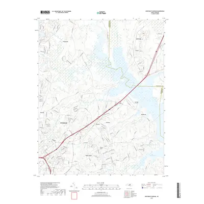
2019 Map of Northeast Durham
USGS Topo · Published 2019About this map
Durham and its northeastern suburbs anchor this landscape at the junction of Durham and Granville counties. The terrain is defined by a series of impoundments and small lakes, including Brinkley Lake, Newcombs Lake, and Lake Hughes, which punctuate the drainage basins of the Little River and Ellerbe Creek. While the urban reach of Durham is evident in the southwest with dense residential streets such as Bundy Ave and Dearborn Dr, the map transitions toward more rural and residential pockets like Fairntosh and Gorman. The presence of Lake Ridge Aero Park and the sprawling Oak Grove Memorial Gardens near Rocky Knoll illustrates the diverse land use at the city's edge, where historical settlements like Cozart and Redwood maintain their identity amidst the expanding road networks of Interstate 85 and US Highway 70.
Find a feature on this map
121 named features on this map. Tap any name to fly to it.
Don’t see what you’re looking for? This feature index may not catch every label — zoom into the map to look around manually.
Map Details
Editions of this 2019 Northeast Durham Map
This is the sole edition of this map. No revisions or reprints were ever made.
Other maps of this area

1943 · Durham South
USGS Topo · 1:62,500

1943 · Raleigh
USGS Topo · 1:62,500

1943 · Creedmoor
USGS Topo · 1:62,500

1944 · Creedmoor
USGS Topo · 1:62,500

1951 · Raleigh
USGS Topo · 1:62,500

1951 · Durham South
USGS Topo · 1:62,500

1951 · Durham North
USGS Topo · 1:62,500

1953 · Raleigh
USGS Topo · 1:250,000

1953 · Greensboro
USGS Topo · 1:250,000

1954 · Greensboro
USGS Topo · 1:250,000