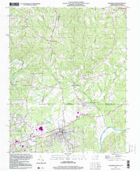
1997 Map of Northeast Eden
USGS Topo · Published 2000About this map
The Dan River and Smith River define this North Carolina-Virginia borderland, where the industrial and residential development of Eden anchors the southern portion of the sheet. This late-20th-century update reveals a landscape shaped by both early settlement patterns and modern infrastructure, including the Norfolk and Western rail lines and the Tri-City Airport. Notable industrial and textile history is evident in the Draper and Spray areas, while the northern terrain transitions into the Piedmont hills of Henry and Pittsylvania counties in Virginia.
Find a feature on this map
62 named features on this map. Tap any name to fly to it.
Don’t see what you’re looking for? This feature index may not catch every label — zoom into the map to look around manually.
Map Details
Editions of this 1997 Northeast Eden Map
This is the sole edition of this map. No revisions or reprints were ever made.
Other maps of this area

1924 · Martinsville
USGS Topo · 1:48,000

1924 · Draper
USGS Topo · 1:48,000

1926 · Martinsville
USGS Topo · 1:62,500

1926 · Draper
USGS Topo · 1:62,500

1927 · Martinsville
USGS Topo · 1:62,500

1944 · Martinsville
USGS Topo · 1:62,500

1944 · Draper
USGS Topo · 1:62,500

1953 · Greensboro
USGS Topo · 1:250,000

1954 · Greensboro
USGS Topo · 1:250,000

1962 · Greensboro
USGS Topo · 1:250,000