
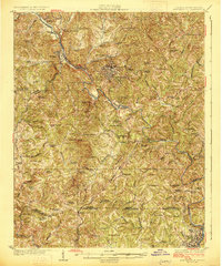
1926 Map of Martinsville
USGS Topo · Published 1926About this map
Martinsville serves as the central hub of this 1920s survey, situated at the junction of the Norfolk and Western Railway and the Danville and Western Railway. The landscape is defined by the winding course of the Smith River, which powers the industrial and agricultural life of Henry County. Notable local landmarks like the Rough and Ready Mill and Rangeleys Store indicate a rural economy still deeply connected to small-scale commerce and water-driven processing.
Find a feature on this map
82 named features on this map. Tap any name to fly to it.
Don’t see what you’re looking for? This feature index may not catch every label — zoom into the map to look around manually.
Map Details
Editions of this 1926 Martinsville Map
2 editions found
Other maps of this area

1922 · Callands
USGS Topo · 1:48,000

1924 · Martinsville
USGS Topo · 1:48,000

1924 · Draper
USGS Topo · 1:48,000

1924 · Callands
USGS Topo · 1:62,500

1925 · Rocky Mount
USGS Topo · 1:48,000

1926 · Critz
USGS Topo · 1:48,000

1926 · Draper
USGS Topo · 1:62,500

1927 · Rocky Mount
USGS Topo · 1:62,500

1927 · Martinsville
USGS Topo · 1:62,500

1928 · Critz
USGS Topo · 1:62,500