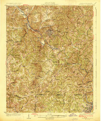
1926 Map of Martinsville
USGS Topo · Published 1926About this map
Martinsville serves as the industrial and civic anchor of Henry County in the mid-1920s, situated along a prominent bend of the Smith River. The landscape is defined by its deep connectivity to the regional rail network, with the Norfolk and Western Railway and the Danville and Western Railway intersecting to move goods and people through the Piedmont. Significant industrial footprints are evident at Fieldale and Firestone, reflecting the textile and manufacturing growth of the era.
Find a feature on this map
86 named features on this map. Tap any name to fly to it.
Don’t see what you’re looking for? This feature index may not catch every label — zoom into the map to look around manually.
Map Details
Editions of this 1926 Martinsville Map
2 editions found
Other maps of this area

1922 · Callands
USGS Topo · 1:48,000

1924 · Martinsville
USGS Topo · 1:48,000

1924 · Draper
USGS Topo · 1:48,000

1924 · Callands
USGS Topo · 1:62,500

1925 · Rocky Mount
USGS Topo · 1:48,000

1926 · Martinsville
USGS Topo · 1:62,500

1926 · Critz
USGS Topo · 1:48,000

1926 · Draper
USGS Topo · 1:62,500

1927 · Rocky Mount
USGS Topo · 1:62,500

1927 · Martinsville
USGS Topo · 1:62,500