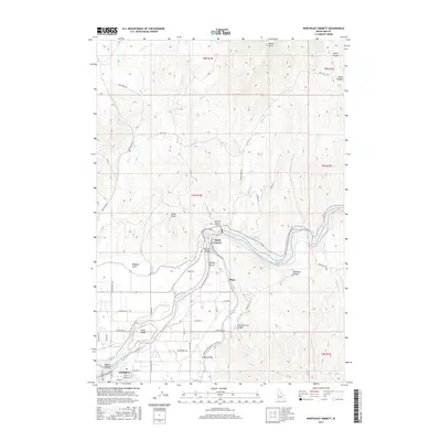
2017 Map of Northeast Emmett
USGS Topo · Published 2017About this map
The Payette River carves through this Idaho landscape, feeding an intricate network of irrigation infrastructure essential to the Emmett Valley. The southern portion of the map is dominated by the northern reaches of Emmett, where the river splits around Fuller Island and Ross Island. This area showcases the complex water management systems of the early 21st century, including the Farmers Cooperative Canal, Last Chance Canal, and the Black Canyon Canal. To the northeast, the Black Canyon Reservoir is held back by the dam in Black Canyon. The terrain rises sharply from the river valley toward the northern heights of Squaw Butte. Local history is preserved in the naming of numerous drainages and canyons, such as Kingman Gulch, Shellrock Canyon, and Picket Corral Canyon, while rural settlements like Plaza sit along the transition from irrigated bottomlands to the arid uplands.
Find a feature on this map
61 named features on this map. Tap any name to fly to it.
Don’t see what you’re looking for? This feature index may not catch every label — zoom into the map to look around manually.
Map Details
Editions of this 2017 Northeast Emmett Map
This is the sole edition of this map. No revisions or reprints were ever made.
Other maps of this area

1892 · Boise
USGS Topo · 1:125,000

1894 · Squaw Creek
USGS Topo · 1:125,000

1897 · Boise
USGS Topo · 1:125,000

1897 · Weiser
USGS Topo · 1:125,000

1898 · Nampa
USGS Topo · 1:125,000

1953 · Montour
USGS Topo · 1:62,500

1955 · Baker
USGS Topo · 1:250,000

1955 · Boise
USGS Topo · 1:250,000

1958 · Boise
USGS Topo · 1:250,000

1959 · Baker
USGS Topo · 1:250,000