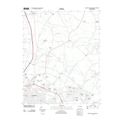
2010 Map of Northeast Goldsboro
USGS Topo · Published 2010About this map
The city of Goldsboro anchors the southwestern portion of this coastal plain landscape, which is defined by a dense network of suburban developments and traditional crossroads communities. Numerous residential pockets such as Winbon Acres, Tiffany Gardens, and Coley Acres reveal the area's growth patterns near the regional hub of Goldsboro. To the north, the town of Pikeville is marked by its Pikeville Post Office and Pikeville Cemetery, while rural points like Musgrave Crossroads and Patetown maintain their distinct identities amidst the winding watercourses of Stoney Creek and The Slough. The landscape is also shaped by aviation and water management, featuring the Goldsboro-Wayne Municipal Airport and the Thomas Bass Dam. Genealogists will find particular value in the several burial grounds shown, including Greenleaf Cemetery and Old Mill Cemetery.
Find a feature on this map
91 named features on this map. Tap any name to fly to it.
Don’t see what you’re looking for? This feature index may not catch every label — zoom into the map to look around manually.
Map Details
Editions of this 2010 Northeast Goldsboro Map
This is the sole edition of this map. No revisions or reprints were ever made.
Other maps of this area

1902 · Kenly
USGS Topo · 1:62,500

1903 · Kenly
USGS Topo · 1:62,500

1904 · Wilson
USGS Topo · 1:62,500

1953 · Rocky Mount
USGS Topo · 1:250,000

1953 · Raleigh
USGS Topo · 1:250,000

1954 · Rocky Mount
USGS Topo · 1:250,000

1954 · Raleigh
USGS Topo · 1:250,000

1957 · Goldsboro
USGS Topo · 1:62,500

1974 · Northwest Goldsboro
USGS Topo · 1:24,000

1974 · Southwest Goldsboro
USGS Topo · 1:24,000