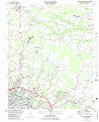
1983 Map of Northeast Goldsboro
USGS Topo · Published 1983About this map
Goldsboro expands toward the northeast in this early 1980s landscape, where the traditional agricultural grid of Wayne County meets modern institutional growth. The Seaboard rail line and the Atlantic and East Carolina railroad anchor the transit network, connecting the city to outlying communities like Pikeville and Patetown. Education and healthcare infrastructure are prominent, with the sprawling campuses of Wayne Community College and Wayne Co Mem Hospital established as major local landmarks alongside the Goldsboro-Wayne Municipal Airport.
Find a feature on this map
73 named features on this map. Tap any name to fly to it.
Don’t see what you’re looking for? This feature index may not catch every label — zoom into the map to look around manually.
Map Details
Editions of this 1983 Northeast Goldsboro Map
This is the sole edition of this map. No revisions or reprints were ever made.
Other maps of this area

1902 · Kenly
USGS Topo · 1:62,500

1903 · Kenly
USGS Topo · 1:62,500

1904 · Wilson
USGS Topo · 1:62,500

1953 · Rocky Mount
USGS Topo · 1:250,000

1953 · Raleigh
USGS Topo · 1:250,000

1954 · Rocky Mount
USGS Topo · 1:250,000

1954 · Raleigh
USGS Topo · 1:250,000

1957 · Goldsboro
USGS Topo · 1:62,500

1974 · Northwest Goldsboro
USGS Topo · 1:24,000

1974 · Southwest Goldsboro
USGS Topo · 1:24,000