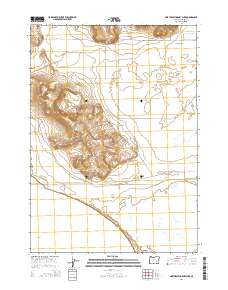
2014 Map of Northeast Harney Lake
USGS Topo · Published 2014About this map
Sunset Valley occupies the northern reaches of this high desert terrain, where the landscape transitions into the basin of Harney Lake. This 2014 survey documents the hydrography of the region, specifically the proximity of Harney Lake to Mud Lake in the southern sections. The map illustrates a sparse network of rural transit lines that support the local ranching and agricultural economy, including OO Ranch Rd and McCanna Rd. These roads provide critical access through the various township and range boundaries, such as t26s r30e and t26s r31e, linking isolated springs and valleys across the Harney County interior. The presence of Weaver Springs Ln in the north suggests the importance of water sources in this arid environment.
Find a feature on this map
13 named features on this map. Tap any name to fly to it.
Don’t see what you’re looking for? This feature index may not catch every label — zoom into the map to look around manually.
Map Details
Editions of this 2014 Northeast Harney Lake Map
This is the sole edition of this map. No revisions or reprints were ever made.
Other maps of this area

1955 · Burns
USGS Topo · 1:250,000

1958 · Burns
USGS Topo · 1:250,000

1959 · Burns
USGS Topo · 1:250,000

1959 · Dog Mountain
USGS Topo · 1:62,500

1959 · Lawen
USGS Topo · 1:62,500

1967 · Coyote Buttes
USGS Topo · 1:24,000

1978 · Malheur Lake
USGS Topo · 1:100,000
1980 · Southwest Harney Lake
USGS Topo · 1:24,000
1980 · Southeast Harney Lake
USGS Topo · 1:24,000
1990 · The Narrows
USGS Topo · 1:24,000