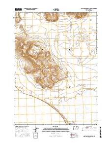
2017 Map of Northeast Harney Lake
USGS Topo · Published 2017About this map
Harney Lake and Mud Lake define the southern landscape of this high desert terrain in Harney County, Oregon. The northeastern shorelines are captured in detail, showing a complex network of wetlands and seasonal basins typical of the Great Basin drainage system. In the north, Sunset Valley provides a flat expanse contrasted by the rising contours of volcanic ridges and hills that separate it from the lake beds.
Find a feature on this map
14 named features on this map. Tap any name to fly to it.
Don’t see what you’re looking for? This feature index may not catch every label — zoom into the map to look around manually.
Map Details
Editions of this 2017 Northeast Harney Lake Map
This is the sole edition of this map. No revisions or reprints were ever made.
Other maps of this area

1955 · Burns
USGS Topo · 1:250,000

1958 · Burns
USGS Topo · 1:250,000

1959 · Burns
USGS Topo · 1:250,000

1959 · Dog Mountain
USGS Topo · 1:62,500

1959 · Lawen
USGS Topo · 1:62,500

1967 · Coyote Buttes
USGS Topo · 1:24,000

1978 · Malheur Lake
USGS Topo · 1:100,000
1980 · Southwest Harney Lake
USGS Topo · 1:24,000
1980 · Southeast Harney Lake
USGS Topo · 1:24,000
1990 · The Narrows
USGS Topo · 1:24,000