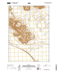
2020 Map of Northeast Harney Lake
USGS Topo · Published 2020About this map
Harney Lake and the marshy expanses of Mud Lake dominate the southern portion of this high desert landscape in Harney County. This modern survey illustrates a remote corner of the Oregon basin where seasonal water levels dictate the character of the terrain, particularly within the broad, flat basin of Sunset Valley. The map details a network of rural access routes essential for ranching and land management, including the long stretch of Oo Ranch Rd that skirts the northern edges of the wetlands. Other corridors like Weaver Springs Rd and Mccanna Rd provide the primary infrastructure through the interior hills. The mapping reflects the enduring ranching heritage of the region, where roads are named for established families and landmarks like Castle Rd and Raven Rd navigate the sparse, arid elevations above the lake beds.
Find a feature on this map
13 named features on this map. Tap any name to fly to it.
Don’t see what you’re looking for? This feature index may not catch every label — zoom into the map to look around manually.
Map Details
Editions of this 2020 Northeast Harney Lake Map
This is the sole edition of this map. No revisions or reprints were ever made.
Other maps of this area

1955 · Burns
USGS Topo · 1:250,000

1958 · Burns
USGS Topo · 1:250,000

1959 · Burns
USGS Topo · 1:250,000

1959 · Dog Mountain
USGS Topo · 1:62,500

1959 · Lawen
USGS Topo · 1:62,500

1967 · Coyote Buttes
USGS Topo · 1:24,000

1978 · Malheur Lake
USGS Topo · 1:100,000
1980 · Southwest Harney Lake
USGS Topo · 1:24,000
1980 · Southeast Harney Lake
USGS Topo · 1:24,000
1990 · The Narrows
USGS Topo · 1:24,000