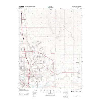
2013 Map of Northeast Pueblo
USGS Topo · Published 2013About this map
Pueblo serves as the focal point of this 2013 topographic survey, illustrating the convergence of industrial legacy and modern infrastructure. The Arkansas River and Fountain Creek frame the urban center, where the historical footprint of industry is marked by Smelter Hill and the S Colorado Power Company Reservoir. North of the city, the campus of Colorado State University-Pueblo stands near the established neighborhoods of Eden and Fearnowville. The landscape transitions from the dense street grids of the city to the prominent heights of Baculite Mesa and Goat Hill. To the east, the Pueblo Memorial Airport and the settlement of Baxter reflect the region's expansive development. Significant cultural and historical sites are noted, including the Masonic Cem and Jacob Fowlers Lookout, providing a detailed look at how the community has organized itself around both its water sources and its varied terrain.
Find a feature on this map
178 named features on this map. Tap any name to fly to it.
Don’t see what you’re looking for? This feature index may not catch every label — zoom into the map to look around manually.
Map Details
Editions of this 2013 Northeast Pueblo Map
This is the sole edition of this map. No revisions or reprints were ever made.
Other maps of this area

1891 · Pueblo
USGS Topo · 1:125,000

1891 · Nepesta
USGS Topo · 1:125,000

1893 · Nepesta
USGS Topo · 1:125,000

1894 · Pueblo
USGS Topo · 1:125,000

1896 · Pueblo
USGS Topo · 1:125,000

1897 · Pueblo
USGS Topo · 1:125,000

1904 · Nepesta
USGS Topo · 1:125,000

1954 · Pueblo
USGS Topo · 1:250,000

1957 · Pueblo
USGS Topo · 1:250,000

1958 · Pueblo
USGS Topo · 1:250,000