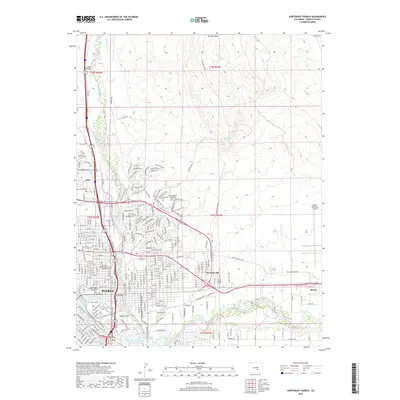
2019 Map of Northeast Pueblo
USGS Topo · Published 2019About this map
The city of Pueblo and its northeastern expansion are documented in this 2019 survey, revealing a landscape where urban development meets the high desert plateaus of the Front Range. The map details the academic sprawl of Colorado State University Pueblo and the surrounding residential sectors of Eden and Fearnowville. The terrain is defined by the Arkansas River and Fountain Creek, with human engineering visible in the Greenville Ditch, Booth Canal, and the North Mills Clarifying Pond. Significant civic and spiritual landmarks are recorded, including the Dennis Maes Pueblo Judicial Building, Ascension Episcopal Church Columbarium, and historical burial grounds like Masonic Cem and B'Nai Jacob Cem. To the east, the vast grounds of Pueblo Memorial Airport dominate the plains, while the residential heights of Goat Hill and Smelter Hill overlook the river valley, marking the region's industrial and social evolution.
Find a feature on this map
238 named features on this map. Tap any name to fly to it.
Don’t see what you’re looking for? This feature index may not catch every label — zoom into the map to look around manually.
Map Details
Editions of this 2019 Northeast Pueblo Map
This is the sole edition of this map. No revisions or reprints were ever made.
Other maps of this area

1891 · Pueblo
USGS Topo · 1:125,000

1891 · Nepesta
USGS Topo · 1:125,000

1893 · Nepesta
USGS Topo · 1:125,000

1894 · Pueblo
USGS Topo · 1:125,000

1896 · Pueblo
USGS Topo · 1:125,000

1897 · Pueblo
USGS Topo · 1:125,000

1904 · Nepesta
USGS Topo · 1:125,000

1954 · Pueblo
USGS Topo · 1:250,000

1957 · Pueblo
USGS Topo · 1:250,000

1958 · Pueblo
USGS Topo · 1:250,000