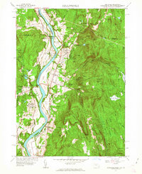
1961 Map of Northfield
USGS Topo · Published 1963About this map
The Connecticut River serves as the central artery for this tri-state borderland, where Massachusetts, New Hampshire, and Vermont converge. The landscape is defined by its educational and agricultural heritage, notably anchored by the Northfield School for Girls and the Northfield School for Boys near Mt Hermon. This 1961 revision of earlier planetable surveys reveals a valley floor composed of distinct named plains and meadows, such as Beers Plain and Pauchaug Meadow, which supported the river-bottom farming economy. Transport is dominated by the parallel routes of the Boston and Maine and Central Vermont railroads, which once connected small hubs like Gill Station and East Northfield Station to larger regional markets. Beyond the valley, the terrain rises sharply into the Northfield State Forest and the evocative rocky heights of Satans Kingdom.
Find a feature on this map
99 named features on this map. Tap any name to fly to it.
Don’t see what you’re looking for? This feature index may not catch every label — zoom into the map to look around manually.
Map Details
Editions of this 1961 Northfield Map
2 editions found
Other maps of this area

1887 · Warwick
USGS Topo · 1:62,500

1889 · Warwick
USGS Topo · 1:62,500

1890 · Greenfield
USGS Topo · 1:62,500

1891 · Brattleboro
USGS Topo · 1:62,500

1893 · Brattleboro
USGS Topo · 1:62,500

1894 · Greenfield
USGS Topo · 1:62,500

1894 · Warwick
USGS Topo · 1:62,500

1898 · Keene
USGS Topo · 1:62,500

1932 · Brattleboro
USGS Topo · 1:48,000

1932 · Warwick
USGS Topo · 1:48,000