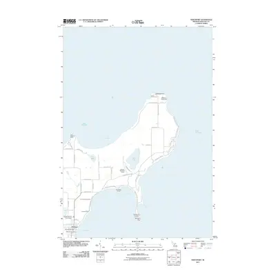
2011 Map of Northport
USGS Topo · Published 2011About this map
The tip of the Leelanau Peninsula comes into sharp focus during this era, dominated by the long-standing maritime influence of Lake Michigan. At the northernmost point, the Grand Traverse Light stands at Lighthouse Point, marking the entrance to the bay. The village of Northport serves as the primary hub of activity, supported by the G Marsten Dame Marina and local maritime infrastructure like the Northport Bay Boat Yard.
Find a feature on this map
49 named features on this map. Tap any name to fly to it.
Don’t see what you’re looking for? This feature index may not catch every label — zoom into the map to look around manually.
Map Details
Editions of this 2011 Northport Map
This is the sole edition of this map. No revisions or reprints were ever made.
Other maps of this area

1954 · Central Lake
USGS Topo · 1:62,500

1954 · Charlevoix
USGS Topo · 1:62,500

1955 · Cheboygan
USGS Topo · 1:250,000

1957 · Northport
USGS Topo · 1:62,500

1958 · Cheboygan
USGS Topo · 1:250,000

1983 · Northport
USGS Topo · 1:25,000

1983 · Omena
USGS Topo · 1:24,000
1983 · Northport NW
USGS Topo · 1:25,000
1983 · Gills Pier
USGS Topo · 1:25,000

1984 · Charlevoix
USGS Topo · 1:100,000