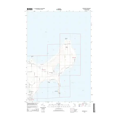
2014 Map of Northport
USGS Topo · Published 2014About this map
The Leelanau Peninsula tapers toward its northernmost tip at Lighthouse Point, where the land meets the vast expanse of Lake Michigan. The village of Northport serves as the primary settlement on this northern reach, positioned along the shores of Northport Bay. This area is defined by its maritime landscape, featuring prominent coastal landmarks such as Cat Head Point and Northport Point. Inland, the terrain is dotted with small water bodies like Leg Lake and Mud Lake. Local history is anchored by the Leelanau Township Number One and Two Cem and the Woolsey Memorial Airport. The map also reveals the localized road network, including N Northport Point Rd and CR 640, which connect the scattered bays and points of this distinct Michigan geography.
Find a feature on this map
52 named features on this map. Tap any name to fly to it.
Don’t see what you’re looking for? This feature index may not catch every label — zoom into the map to look around manually.
Map Details
Editions of this 2014 Northport Map
This is the sole edition of this map. No revisions or reprints were ever made.
Other maps of this area

1954 · Central Lake
USGS Topo · 1:62,500

1954 · Charlevoix
USGS Topo · 1:62,500

1955 · Cheboygan
USGS Topo · 1:250,000

1957 · Northport
USGS Topo · 1:62,500

1958 · Cheboygan
USGS Topo · 1:250,000

1983 · Northport
USGS Topo · 1:25,000

1983 · Omena
USGS Topo · 1:24,000
1983 · Northport NW
USGS Topo · 1:25,000
1983 · Gills Pier
USGS Topo · 1:25,000

1984 · Charlevoix
USGS Topo · 1:100,000