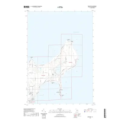
2019 Map of Northport
USGS Topo · Published 2019About this map
The tip of the Leelanau Peninsula comes into sharp focus in this 21st-century record, where the village of Northport serves as the southern anchor. The landscape is defined by its deep relationship with Lake Michigan, featuring prominent landforms like Lighthouse Point and Cat Head Point. Recreational and municipal infrastructure is well-documented, from the Leelanau State Park - Mud Lake Trail and Winter Sports Trail to the uniquely positioned Woolsey Memorial Airport. Local history is preserved through the mapping of the Leelanau Township Number One and Two Cem and the Northport Point Columbarium Cem, while the interior is dotted with significant water bodies such as Mud Lake and Leg Lake. This survey illustrates how the northern reaches of the peninsula balance conservation areas with developed points and bays.
Find a feature on this map
81 named features on this map. Tap any name to fly to it.
Don’t see what you’re looking for? This feature index may not catch every label — zoom into the map to look around manually.
Map Details
Editions of this 2019 Northport Map
This is the sole edition of this map. No revisions or reprints were ever made.
Other maps of this area

1954 · Central Lake
USGS Topo · 1:62,500

1954 · Charlevoix
USGS Topo · 1:62,500

1955 · Cheboygan
USGS Topo · 1:250,000

1957 · Northport
USGS Topo · 1:62,500

1958 · Cheboygan
USGS Topo · 1:250,000

1983 · Northport
USGS Topo · 1:25,000

1983 · Omena
USGS Topo · 1:24,000
1983 · Northport NW
USGS Topo · 1:25,000
1983 · Gills Pier
USGS Topo · 1:25,000

1984 · Charlevoix
USGS Topo · 1:100,000