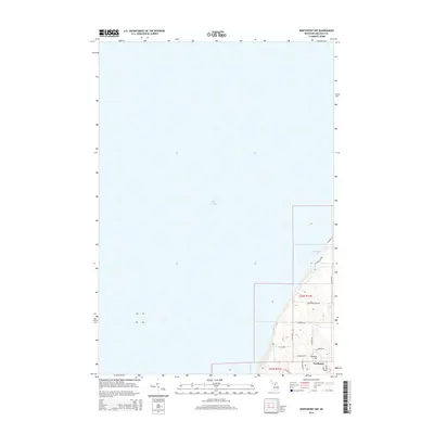
2014 Map of Northport NW
USGS Topo · Published 2014About this map
Lake Michigan defines the western expanse of this coastal survey, where the Leelanau Peninsula meets the open water. The northern reaches of Northport are visible at the southern edge of the sheet, providing a look at the residential grid near Bramen Hill before the landscape transitions to the rural road networks of Leelanau Township. The shoreline is punctuated by Christmas Cove, a distinct maritime feature accessed by winding coastal routes like N Island View Dr and E Elnora Dr. Inland, the geography is characterized by family-named thoroughfares and agricultural sections, including E Garthe Rd and E Melkild Rd, which navigate the elevation changes between the high ground and the lake shore. This 2014 edition documents the modern layout of this cherry-growing region, preserving the exact placement of local connectors such as N Nelson Rd and N Foxview Dr as they serve the residential pockets along the peninsula's edge.
Find a feature on this map
19 named features on this map. Tap any name to fly to it.
Don’t see what you’re looking for? This feature index may not catch every label — zoom into the map to look around manually.
Map Details
Editions of this 2014 Northport NW Map
This is the sole edition of this map. No revisions or reprints were ever made.
Other maps of this area

1955 · Cheboygan
USGS Topo · 1:250,000

1956 · South Fox Island
USGS Topo · 1:62,500

1957 · Northport
USGS Topo · 1:62,500

1958 · Cheboygan
USGS Topo · 1:250,000

1983 · Northport
USGS Topo · 1:25,000

1983 · Omena
USGS Topo · 1:24,000
1983 · Northport NW
USGS Topo · 1:25,000
1983 · Gills Pier
USGS Topo · 1:25,000
1983 · Leland
USGS Topo · 1:25,000

1984 · Charlevoix
USGS Topo · 1:100,000