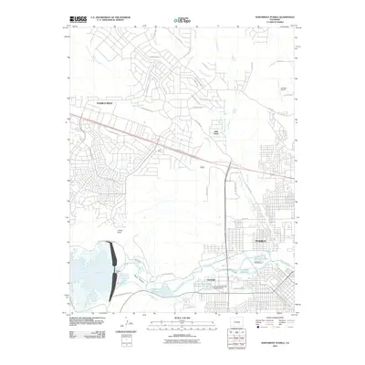
2010 Map of Northwest Pueblo
USGS Topo · Published 2010About this map
Pueblo West dominates the northwestern landscape of this 2010 survey, showing the extensive residential street grid developed north of the Arkansas River. The waterway is heavily managed in this reach, anchored by the massive Pueblo Dam which forms the Pueblo Reservoir. Downstream, the river's flow is diverted through a complex irrigation network including the West Pueblo Ditch and the Bessemer Ditch, reflecting the region's historical reliance on water rights for both agriculture and urban growth.
Find a feature on this map
52 named features on this map. Tap any name to fly to it.
Don’t see what you’re looking for? This feature index may not catch every label — zoom into the map to look around manually.
Map Details
Editions of this 2010 Northwest Pueblo Map
This is the sole edition of this map. No revisions or reprints were ever made.
Other maps of this area

1891 · Pueblo
USGS Topo · 1:125,000

1894 · Pueblo
USGS Topo · 1:125,000

1896 · Pueblo
USGS Topo · 1:125,000

1897 · Pueblo
USGS Topo · 1:125,000

1954 · Pueblo
USGS Topo · 1:250,000

1957 · Pueblo
USGS Topo · 1:250,000

1958 · Pueblo
USGS Topo · 1:250,000
1960 · Pinon
USGS Topo · 1:24,000

1960 · Southeast Pueblo
USGS Topo · 1:24,000
1961 · Steele Hollow
USGS Topo · 1:24,000