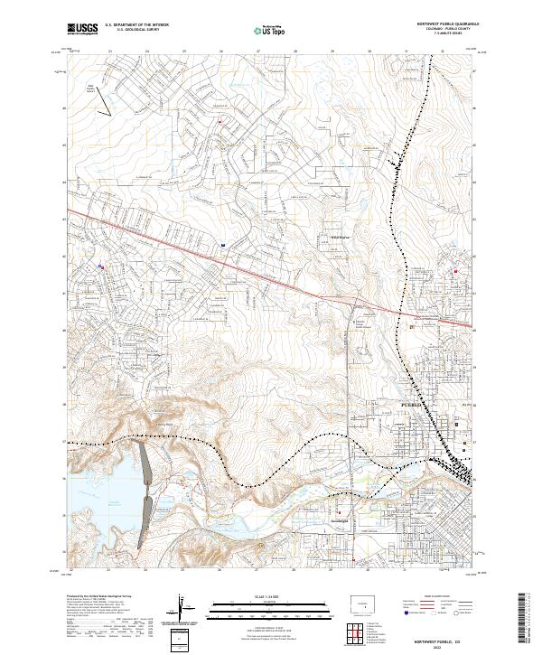
2022 Map of Northwest Pueblo
USGS Topo · Published 2022About this map
Pueblo expands toward its northwestern edges in this 2022 survey, showcasing the sophisticated water management systems that define this high-plains landscape. The southern portion of the map is dominated by the Pueblo Reservoir, a critical hydrological feature fed by the Arkansas River and Boggs Creek. The complex network of irrigation and utility infrastructure is evident through the Bessemer Ditch, W Pueblo Ditch, and the Pueblo Intake.
Find a feature on this map
392 named features on this map. Tap any name to fly to it.
Don’t see what you’re looking for? This feature index may not catch every label — zoom into the map to look around manually.
Map Details
Editions of this 2022 Northwest Pueblo Map
This is the sole edition of this map. No revisions or reprints were ever made.
Other maps of this area

1891 · Pueblo
USGS Topo · 1:125,000

1894 · Pueblo
USGS Topo · 1:125,000

1896 · Pueblo
USGS Topo · 1:125,000

1897 · Pueblo
USGS Topo · 1:125,000

1954 · Pueblo
USGS Topo · 1:250,000

1957 · Pueblo
USGS Topo · 1:250,000

1958 · Pueblo
USGS Topo · 1:250,000
1960 · Pinon
USGS Topo · 1:24,000

1960 · Southeast Pueblo
USGS Topo · 1:24,000
1961 · Steele Hollow
USGS Topo · 1:24,000