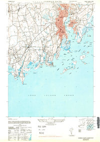
1947 Map of Norwalk South
USGS Topo · Published 1947About this map
Norwalk and its neighboring coastal boroughs are presented here just after the war, showing a landscape defined by its deep estuaries and industrial waterfronts. The New York New Haven and Hartford railroad cuts a vital path across the terrain, linking settlements like Noroton Heights, Darien, and Rowayton. The map reveals the intricate shoreline of the Long Island Sound, where numerous islands such as Sheffield Island and Chimon Island protect the approaches to Norwalk Harbor. Inland, the area retains significant open space and institutional grounds, including the Ferndale Retreat and Tokeneke Park. The industrial character of the mid-century era is grounded by the presence of the Sewage Disposal Plant and extensive greenhouses, contrasting with the growing residential footprints of South Norwalk and East Norwalk.
Find a feature on this map
80 named features on this map. Tap any name to fly to it.
Don’t see what you’re looking for? This feature index may not catch every label — zoom into the map to look around manually.
Map Details
Editions of this 1947 Norwalk South Map
This is the sole edition of this map. No revisions or reprints were ever made.
Other maps of this area

1892 · Stamford
USGS Topo · 1:62,500

1892 · Norwalk
USGS Topo · 1:62,500

1893 · Stamford
USGS Topo · 1:62,500

1893 · Norwalk
USGS Topo · 1:62,500

1897 · Oyster Bay
USGS Topo · 1:62,500

1898 · Oyster Bay
USGS Topo · 1:62,500

1899 · Stamford
USGS Topo · 1:62,500

1900 · Oyster Bay
USGS Topo · 1:62,500

1901 · Northport
USGS Topo · 1:62,500

1903 · Northport
USGS Topo · 1:62,500