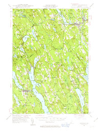
1946 Map of Norway
USGS Topo · Published 1963About this map
Pennessee wassee Lake and the Androscoggin River anchor this mid-century survey of Oxford County, where the landscape is defined by long, narrow lakes and a network of small upland settlements. The town of Norway serves as a central hub, while smaller crossroads like Scribners Mill and Bolsters Mills reflect the area's historical reliance on water power along the Crooked River. Local education and social structure are clearly visible through several district schools, including Chapel District Sch and the South Harrison Sch. Geologists and genealogists can trace family landmarks like McWain Hill or Pike Hill, and locate historical community sites such as the Bell Hill Meeting House and the Fairgrounds. The map also captures the path of an Underground pipe line, a modern industrial addition to the traditional timber and farming terrain of the Oxford Co and Cumberland Co borderlands.
Find a feature on this map
175 named features on this map. Tap any name to fly to it.
Don’t see what you’re looking for? This feature index may not catch every label — zoom into the map to look around manually.
Map Details
Editions of this 1946 Norway Map
4 editions found

Other maps of this area

1894 · Gray
USGS Topo · 1:62,500

1896 · Norway
USGS Topo · 1:62,500

1896 · Sebago
USGS Topo · 1:62,500

1898 · Gray
USGS Topo · 1:62,500

1908 · Poland
USGS Topo · 1:62,500

1909 · Fryeburg
USGS Topo · 1:62,500

1910 · Kezar Falls
USGS Topo · 1:48,000

1911 · Fryeburg
USGS Topo · 1:62,500

1911 · Kezar Falls
USGS Topo · 1:62,500

1911 · Bryant Pond
USGS Topo · 1:62,500