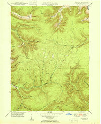
1950 Map of Norwich
USGS Topo · Published 1950About this map
Norwich and the surrounding township character are defined by a complex network of narrow valleys and high ridges in McKean County. At the confluence of the East Branch and Hamlin Run, the waters form Potato Creek, which serves as the primary drainage for this upland territory. The landscape is heavily marked by industrial infrastructure from the mid-century, specifically a prominent Pipe Line traversing the northern ridges and a network of unimproved roads that suggest active timber or resource extraction during the late 1940s. Local family names and geographic markers are preserved in labels like Evans Hill, Sackett Hol, and O'Brien Hollow. The terrain transitions from the high elevations of Dividing Ridge down through countless named runs and hollows, including Stone Chimney Hol and Pigeon Hollow, illustrating the deeply dissected nature of the plateau at this time.
Find a feature on this map
42 named features on this map. Tap any name to fly to it.
Don’t see what you’re looking for? This feature index may not catch every label — zoom into the map to look around manually.
Map Details
Editions of this 1950 Norwich Map
This is the sole edition of this map. No revisions or reprints were ever made.
Other maps of this area

1933 · Smethport
USGS Topo · 1:62,500

1934 · Coudersport
USGS Topo · 1:48,000

1937 · Smethport
USGS Topo · 1:62,500

1938 · Coudersport
USGS Topo · 1:62,500

1948 · Crosby
USGS Topo · 1:62,500

1948 · Emporium
USGS Topo · 1:62,500

1948 · Keating Summit
USGS Topo · 1:24,000

1948 · Emporium
USGS Topo · 1:24,000

1948 · Wildwood Fire Tower
USGS Topo · 1:24,000

1948 · Rich Valley
USGS Topo · 1:24,000