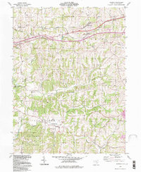
1994 Map of Norwich
USGS Topo · Published 1998About this map
Salt Creek and Rich Hill townships define this eastern Ohio landscape during the final decade of the 20th century. The region is marked by a complex network of narrow ridges and stream valleys, including White Eyes Creek, Georges Run, and the Williams Fork. Significant portions of the southern terrain are preserved within Blue Rock State Forest, while the northern portion is bisected by the modern corridor of I-70.
Find a feature on this map
35 named features on this map. Tap any name to fly to it.
Don’t see what you’re looking for? This feature index may not catch every label — zoom into the map to look around manually.
Map Details
Editions of this 1994 Norwich Map
This is the sole edition of this map. No revisions or reprints were ever made.
Other maps of this area

1908 · Conesville
USGS Topo · 1:62,500

1909 · Cambridge
USGS Topo · 1:62,500

1910 · Philo
USGS Topo · 1:62,500

1910 · Conesville
USGS Topo · 1:62,500

1911 · Cumberland
USGS Topo · 1:62,500

1912 · Cambridge
USGS Topo · 1:62,500

1949 · Clarksburg
USGS Topo · 1:250,000

1951 · Canton
USGS Topo · 1:250,000

1953 · Canton
USGS Topo · 1:250,000

1956 · Clarksburg
USGS Topo · 1:250,000