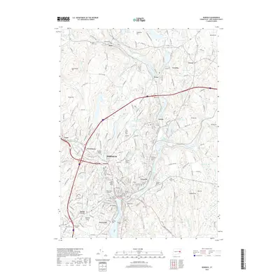
2018 Map of Norwich
USGS Topo · Published 2018About this map
Norwich and its surrounding neighborhoods sit at the critical confluence of the Yantic River, Shetucket River, and Thames River in this 2018 survey. The map details the dense urban and suburban character of Norwichtown, Taftville, Greenville, and Laurel Hill, revealing a landscape shaped by historical industrial water power and modern transit. Notable cultural and genealogical landmarks are frequent, including the Royal Mohegan Burial Ground and the Monhegan Tribal Memorial, honoring the indigenous heritage of the region alongside established sites like the Old Uptown Burying Ground and Saint Mary's and Saint Joseph's Cem. From the campus of Three Rivers Community College to the heights of Jail Hill and Crown Hill, the topography illustrates the transition from riverfront flats to the rising ridges of Ox Hill and Bundy Hill. This map provides a detailed view of the infrastructure and land use within the Thamesville and East Great Plain corridors during the late 2010s.
Find a feature on this map
227 named features on this map. Tap any name to fly to it.
Don’t see what you’re looking for? This feature index may not catch every label — zoom into the map to look around manually.
Map Details
Editions of this 2018 Norwich Map
This is the sole edition of this map. No revisions or reprints were ever made.
Other maps of this area

1889 · Stonington
USGS Topo · 1:62,500

1889 · Moosup
USGS Topo · 1:62,500

1892 · New London
USGS Topo · 1:62,500

1892 · Norwich
USGS Topo · 1:62,500

1893 · Moosup
USGS Topo · 1:62,500

1893 · Stonington
USGS Topo · 1:62,500

1893 · New London
USGS Topo · 1:62,500

1920 · Moosup
USGS Topo · 1:62,500

1921 · New London
USGS Topo · 1:62,500

1921 · Stonington
USGS Topo · 1:62,500