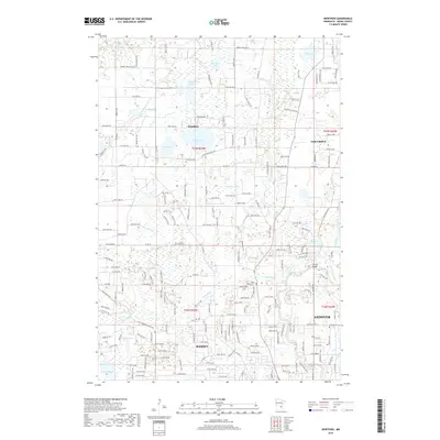
2019 Map of Nowthen
USGS Topo · Published 2019About this map
Nowthen and the surrounding townships of Oak Grove, Ramsey, and Andover characterize this landscape of the Anoka Sand Plain, defined by a dense network of glacial kettle lakes and wetlands. The community of Nowthen sits centrally, bordered by Pickerel Lake and Bass Lake, while the eastern edge is shaped by the winding course of the Rum River and the Faherty Bridge crossing. The map reveals a pattern of modern residential growth interspersed with deep-rooted local history, evidenced by Lakeview Cem, Trott Brook Cem, and Staples Cem. Significant water features like Pinnaker Lake, Goose Lake, and Norris Lake dominate the northern terrain, while Trott Brook meanders across the southern sections. This survey provides a precise record of the transition from rural agricultural plots to suburban development, anchored by thoroughfares such as Viking Blvd NW and Co Hwy 22.
Find a feature on this map
97 named features on this map. Tap any name to fly to it.
Don’t see what you’re looking for? This feature index may not catch every label — zoom into the map to look around manually.
Map Details
Editions of this 2019 Nowthen Map
This is the sole edition of this map. No revisions or reprints were ever made.
Other maps of this area

1902 · Anoka
USGS Topo · 1:62,500

1909 · Rockford
USGS Topo · 1:62,500

1916 · St. Francis
USGS Topo · 1:62,500

1919 · St. Francis
USGS Topo · 1:62,500

1953 · Stillwater
USGS Topo · 1:250,000

1955 · Anoka
USGS Topo · 1:24,000

1955 · Coon Rapids
USGS Topo · 1:24,000

1955 · Anoka
USGS Topo · 1:62,500

1955 · Stillwater
USGS Topo · 1:250,000

1958 · Stillwater
USGS Topo · 1:250,000