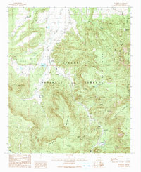
1991 Map of Nutrioso
USGS Topo · Published 1991About this map
The mountain settlement of Nutrioso and the high-elevation ranching land of Colter sit at the heart of this Apache County survey. Located within the Apache National Forest, the landscape is defined by the headwaters of Nutrioso Creek and numerous reservoirs, including Nutrioso Reservoir and Riggs Creek Reservoir. For genealogists and local historians, the map provides precise locations for the Maxwell Cem and Rogers Cemetery, as well as named family landmarks like Jarvis Lake and Watts Creek. The eastern portion of the quadrangle is dominated by the Escudilla Mountain massif and the Escudilla Wilderness, while to the south, the terrain climbs toward Noble Mountain and the Alpine Divide. This 1991 provisional edition captures the established forest road network and early recreational infrastructure, such as the Alpine Divide Campground and Hulsey Lake.
Find a feature on this map
38 named features on this map. Tap any name to fly to it.
Don’t see what you’re looking for? This feature index may not catch every label — zoom into the map to look around manually.
Map Details
Editions of this 1991 Nutrioso Map
This is the sole edition of this map. No revisions or reprints were ever made.
Other maps of this area

1886 · St Johns
USGS Topo · 1:250,000

1892 · St Johns
USGS Topo · 1:250,000

1922 · Nutrioso
USGS Topo · 1:125,000

1954 · Clifton
USGS Topo · 1:250,000

1954 · Saint Johns
USGS Topo · 1:250,000

1957 · Clifton
USGS Topo · 1:250,000

1957 · Saint Johns
USGS Topo · 1:250,000

1958 · Clifton
USGS Topo · 1:250,000

1958 · Saint Johns
USGS Topo · 1:250,000

1958 · Alpine
USGS Topo · 1:62,500