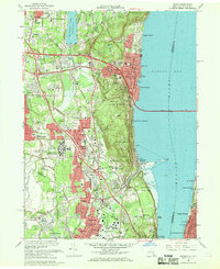
1967 Map of Nyack
USGS Topo · Published 1969About this map
The Hudson River shoreline and its historic riverfront villages define this mid-1960s survey, dominated by the wide expanse of the Tappan Zee. On the western bank, the communities of Nyack, Piermont, and Upper Nyack sit at the foot of dramatic elevations like Hook Mtn and Mt Nebo. The landscape reflects a mix of institutional and educational growth, featuring Rockland State Hospital, St Thomas Aquinas College, and Dominican College. The era's transportation network is fully realized with the Tappan Zee Bridge spanning the water to Dobbs Ferry and Irvington, while the Palisades Interstate Parkway carves through the wooded ridges to the south.
Find a feature on this map
93 named features on this map. Tap any name to fly to it.
Don’t see what you’re looking for? This feature index may not catch every label — zoom into the map to look around manually.
Map Details
Editions of this 1967 Nyack Map
Other maps of this area

1888 · Paterson
USGS Topo · 1:62,500

1891 · Ramapo
USGS Topo · 1:62,500

1891 · Harlem
USGS Topo · 1:62,500

1892 · Paterson
USGS Topo · 1:62,500

1892 · Tarrytown
USGS Topo · 1:62,500

1893 · Tarrytown
USGS Topo · 1:62,500

1893 · Ramapo
USGS Topo · 1:62,500

1897 · Harlem
USGS Topo · 1:62,500

1898 · Harlem
USGS Topo · 1:62,500

1898 · Paterson
USGS Topo · 1:62,500