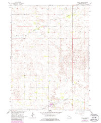
1964 Map of O'Neill SW
USGS Topo · Published 1986About this map
The South Fork of the Elkhorn River defines the southern reaches of this landscape in Holt County, Nebraska. This 1964 survey, updated with 1980s photogrammetric data, captures a rural expanse characterized by the winding drainage of Dry Creek and a complex network of intermittent water features typical of the Nebraska Sandhills. The terrain is marked by a distinctive pattern of hills and depressions, with elevations fluctuating around the 2,000-foot mark across the quadrangle.
Find a feature on this map
7 named features on this map. Tap any name to fly to it.
Don’t see what you’re looking for? This feature index may not catch every label — zoom into the map to look around manually.
Map Details
Editions of this 1964 O'Neill SW Map
2 editions found
Other maps of this area

1955 · O'Neill
USGS Topo · 1:250,000

1958 · O'Neill
USGS Topo · 1:24,000

1958 · Inman
USGS Topo · 1:24,000

1959 · O'Neill
USGS Topo · 1:250,000

1964 · O'Neill SE
USGS Topo · 1:24,000

1964 · Emmet SE
USGS Topo · 1:24,000

1964 · O'Neill SW
USGS Topo · 1:24,000

1964 · Emmet
USGS Topo · 1:24,000

1969 · O'Neill
USGS Topo · 1:250,000

1981 · Chambers East
USGS Topo · 1:24,000