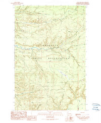
1990 Map of O'Took Prairie
USGS Topo · Published 1990About this map
The Quinault Indian Reservation dominates this 1990 survey, showing a landscape defined by its complex drainage systems and timber resources. The Raft River and its major tributary, the North Fork Raft River, cut across the northern half of the map, while the expansive O'Took Prairie forms a distinct natural opening in the heavy terrain to the southeast. The area is marked by a network of timber-related infrastructure, including numerous unnamed Borrow Pit locations and Gravel Pits used for road maintenance. Historical watercourses such as Crane Creek, Lunch Creek, and O'Took Creek weave through the township lines, illustrating the density of the coastal watershed. The presence of 4wd trails and established camp areas like Camp Creek suggest a landscape managed for both resource extraction and backcountry access in the late twentieth century.
Find a feature on this map
24 named features on this map. Tap any name to fly to it.
Don’t see what you’re looking for? This feature index may not catch every label — zoom into the map to look around manually.
Map Details
Editions of this 1990 O'Took Prairie Map
This is the sole edition of this map. No revisions or reprints were ever made.
Other maps of this area

1943 · Copalis Beach
USGS Topo · 1:250,000

1951 · Copalis Beach
USGS Topo · 1:250,000

1955 · Taholah
USGS Topo · 1:62,500

1955 · Macafee Hill
USGS Topo · 1:62,500

1956 · Destruction Island
USGS Topo · 1:62,500

1956 · Salmon River
USGS Topo · 1:62,500

1957 · Copalis Beach
USGS Topo · 1:250,000

1963 · Copalis Beach
USGS Topo · 1:250,000
1980 · Copalis Beach
USGS Topo · 1:100,000
1982 · Taholah
USGS Topo · 1:24,000