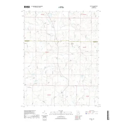
2017 Map of Oak Hill
USGS Topo · Published 2017About this map
The settlement of Oak Hill sits at the intersection of State Hwy CC and N Oak Hill Rd, serving as a central point in this rural landscape spanning the Gasconade Co and Crawford Co line. The terrain is defined by the winding course of the Bourbeuse River and a dense network of smaller drainages like Brush Cr and Souder Cr. This area is particularly rich for genealogical research, with numerous family-named burial grounds scattered across the countryside, including Pinnell Cem, Griffith Cem, and the uniquely named Aunt Pop Cem. Private landholdings are marked by several man-made water bodies such as Kozlowski Lake, Stubblefield Lake, and the multi-named Skinner-Sorth-Koch-Kreider Lake. The road network, composed of routes like Enke Rd and Souders Rd, follows the natural contours of the Ozark hills, connecting isolated farmsteads and historic family cemeteries.
Find a feature on this map
88 named features on this map. Tap any name to fly to it.
Don’t see what you’re looking for? This feature index may not catch every label — zoom into the map to look around manually.
Map Details
Editions of this 2017 Oak Hill Map
This is the sole edition of this map. No revisions or reprints were ever made.
Other maps of this area
1903 · Sullivan
USGS Topo · 1:125,000
1934 · Bland
USGS Topo · 1:62,500
1934 · Redbird
USGS Topo · 1:62,500
1935 · Gerald
USGS Topo · 1:48,000
1937 · Bland
USGS Topo · 1:62,500
1938 · Redbird
USGS Topo · 1:62,500
1941 · Gerald
USGS Topo · 1:62,500
1944 · Gerald
USGS Topo · 1:62,500
1948 · Cuba
USGS Topo · 1:24,000
1948 · Leasburg
USGS Topo · 1:24,000