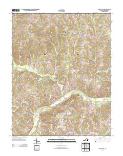
2013 Map of Oak Level
USGS Topo · Published 2013About this map
The Dan River serves as the central artery for this section of Halifax County, defining a landscape of agricultural tradition and riverfront history. At the historic crossing of News Ferry, the river makes a sharp bend near the Ruddy Bottom Shoals, a notable terrain feature for those tracing old water routes and navigability. The area is characterized by numerous small crossroads communities and rural outposts that speak to a dispersed settlement pattern, including Owens Store, Terrys Corner, and Colmans Corner. To the north, the terrain is drained by tributaries such as Birch Cr and Miry Cr, leading toward the upland settlement of Oak Level. For genealogists and local historians, the map preserves the exact location of numerous named family lands and rural hubs like Danripple and Paces during the early 21st century.
Find a feature on this map
65 named features on this map. Tap any name to fly to it.
Don’t see what you’re looking for? This feature index may not catch every label — zoom into the map to look around manually.
Map Details
Editions of this 2013 Oak Level Map
This is the sole edition of this map. No revisions or reprints were ever made.
Other maps of this area

1952 · Milton
USGS Topo · 1:62,500

1953 · South Boston
USGS Topo · 1:62,500

1953 · Greensboro
USGS Topo · 1:250,000

1954 · Greensboro
USGS Topo · 1:250,000

1954 · Halifax
USGS Topo · 1:62,500

1954 · Riceville
USGS Topo · 1:62,500

1956 · Milton
USGS Topo · 1:62,500

1957 · South Boston
USGS Topo · 1:62,500

1962 · Greensboro
USGS Topo · 1:250,000

1966 · Greensboro
USGS Topo · 1:250,000