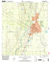
1998 Map of Oakdale
USGS Topo · Published 2003About this map
The Calcasieu River meanders through this Allen Parish landscape, serving as a central geographic anchor for the city of Oakdale. In the late 20th century, the area demonstrates a mix of industrial activity and conservation, with a refinery and sewage disposal facilities situated near the riverbanks, while the expansive West Bay SWMA occupies the western portion of the quadrangle. The transport network is characterized by the Old Railroad Grade and multiple aviation sites, including Oakdale Municipal Airport and Murray Airport.
Find a feature on this map
28 named features on this map. Tap any name to fly to it.
Don’t see what you’re looking for? This feature index may not catch every label — zoom into the map to look around manually.
Map Details
Editions of this 1998 Oakdale Map
This is the sole edition of this map. No revisions or reprints were ever made.
Other maps of this area

1935 · Beaver
USGS Topo · 1:31,680

1935 · Pawnee
USGS Topo · 1:31,680

1935 · Oakdale
USGS Topo · 1:31,680

1942 · Oakdale
USGS Topo · 1:62,500

1947 · Foley
USGS Topo · 1:31,680

1947 · Steep Gully
USGS Topo · 1:31,680

1947 · Pine Chapel
USGS Topo · 1:31,680

1947 · Bond
USGS Topo · 1:31,680

1947 · Elizabeth
USGS Topo · 1:31,680

1948 · Elizabeth
USGS Topo · 1:24,000