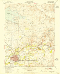
1953 Map of Oakdale
USGS Topo · Published 1955About this map
The Stanislaus River defines the lower third of this mid-century landscape, where the bustling hub of Oakdale serves as a junction for both the Southern Pacific and the Atchison Topeka and Santa Fe Railroad. The town grid shows civic foundations including a High School and Cemetery, while the surrounding agricultural lands are crisscrossed by a complex irrigation network of the Main Canal, Tulloch Canal, and South Main Canal. To the north, the massive Woodward Reservoir dominates the terrain of the Rancheria, providing essential water storage for the valley.
Find a feature on this map
53 named features on this map. Tap any name to fly to it.
Don’t see what you’re looking for? This feature index may not catch every label — zoom into the map to look around manually.
Map Details
Editions of this 1953 Oakdale Map
This is the sole edition of this map. No revisions or reprints were ever made.
Other maps of this area

1915 · Oakdale
USGS Topo · 1:31,680

1915 · Trigo
USGS Topo · 1:31,680

1915 · Paulsell
USGS Topo · 1:31,680

1915 · Thalheim
USGS Topo · 1:31,680

1916 · Riverbank
USGS Topo · 1:31,680

1916 · Waterford
USGS Topo · 1:31,680

1916 · Bachelor Valley
USGS Topo · 1:31,680

1916 · Copperopolis
USGS Topo · 1:62,500

1939 · Modesto East
USGS Topo · 1:62,500

1942 · Farmington
USGS Topo · 1:62,500