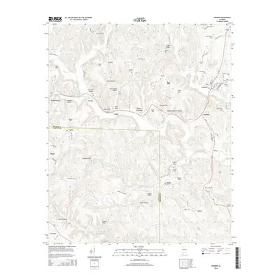
2014 Map of Oakman
USGS Topo · Published 2014About this map
Oakman and its surrounding coal-country settlements define this portion of the Walker and Fayette County line. The landscape is deeply incised by drainages like Wolf Creek and Cane Cr, creating a series of prominent high points and gaps such as Gaines Hill, Key Hill, and Low Gap. Named hollows like Birmingham Hollow and New England Hollow suggest early 20th-century mining communities or family homesteads that followed the contours of the Alabama terrain. Smaller rural centers and junctions, including Coal Valley, West Corona, and Stephenson Crossing, are scattered along the rail and road corridors of Al-18 and Al-69. Genealogists will find a significant concentration of burial sites, from the larger Oakman Cem to smaller family or community plots like Infant Hill Cem, Key Cem, and New Salem Cem, providing a precise record of the area's social geography during the early 21st century.
Find a feature on this map
103 named features on this map. Tap any name to fly to it.
Don’t see what you’re looking for? This feature index may not catch every label — zoom into the map to look around manually.
Map Details
Editions of this 2014 Oakman Map
This is the sole edition of this map. No revisions or reprints were ever made.
Other maps of this area

1893 · Jasper
USGS Topo · 1:125,000

1949 · Parrish
USGS Topo · 1:24,000

1949 · Townley
USGS Topo · 1:24,000

1949 · Jasper
USGS Topo · 1:24,000

1949 · Oakman
USGS Topo · 1:24,000

1949 · Tutwiler School
USGS Topo · 1:24,000

1949 · Wiley
USGS Topo · 1:24,000

1951 · Jasper
USGS Topo · 1:24,000
1951 · Parrish
USGS Topo · 1:24,000
1951 · Tutwiler School
USGS Topo · 1:24,000