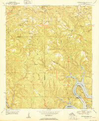
1951 Map of Tutwiler School
USGS Topo · Published 1951About this map
Tutwiler School stands as a focal point in this 1951 record of the hills spanning the Walker and Tuscaloosa county lines. The landscape is defined by the winding waters of the Black Warrior River and the expansive Bankhead Lake to the south, where Camp Creek and White Oak Creek meet the river's edge. This era shows a rural network of small communities and social centers, including Browntown, Fairview, and Canaan. Local education and faith are marked by landmarks such as Reynolds Sch, Freewill Ch, and Cedar Creek Ch. Higher elevations are punctuated by Thompson Mtn and the High Hill Fire Tower, while the intricate drainage system of Shoal Creek and Indian Creek carves through the timbered terrain, reflecting a time before significant modern development altered these traditional Alabamian hollows.
Find a feature on this map
40 named features on this map. Tap any name to fly to it.
Don’t see what you’re looking for? This feature index may not catch every label — zoom into the map to look around manually.
Map Details
Editions of this 1951 Tutwiler School Map
2 editions found
Other maps of this area

1893 · Jasper
USGS Topo · 1:125,000

1899 · Brookwood
USGS Topo · 1:125,000

1927 · Adger
USGS Topo · 1:48,000

1929 · Searles
USGS Topo · 1:48,000

1932 · Yolande
USGS Topo · 1:62,500

1934 · Searles
USGS Topo · 1:62,500

1935 · Port Birmingham
USGS Topo · 1:48,000

1935 · Yolande
USGS Topo · 1:62,500

1938 · Port Birmingham
USGS Topo · 1:62,500

1949 · Parrish
USGS Topo · 1:24,000