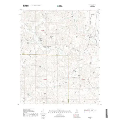
2018 Map of Oakman
USGS Topo · Published 2018About this map
Oakman and its surrounding coal-country settlements define this portion of Walker and Fayette Counties in the late 2010s. The landscape is deeply carved by the drainage networks of Wolf Creek and Blue Water Cr, with the prominent ridge known as The Backbone rising in the southwest. Cultural history is concentrated in several small communities such as Corona and Marietta, while family history is preserved in scattered burial grounds like Swindle Cem and Key Cem. The region's mining heritage is visible in place names like Coal Valley and Coalbed Hollow, while the winding courses of Lockhart Hill RD and Bluewater Trace RD provide the primary connections between these upland settlements. This map offers a modern look at the enduring rural layout of a region historically shaped by timber and resource extraction.
Find a feature on this map
105 named features on this map. Tap any name to fly to it.
Don’t see what you’re looking for? This feature index may not catch every label — zoom into the map to look around manually.
Map Details
Editions of this 2018 Oakman Map
This is the sole edition of this map. No revisions or reprints were ever made.
Other maps of this area

1893 · Jasper
USGS Topo · 1:125,000

1949 · Parrish
USGS Topo · 1:24,000

1949 · Townley
USGS Topo · 1:24,000

1949 · Jasper
USGS Topo · 1:24,000

1949 · Oakman
USGS Topo · 1:24,000

1949 · Tutwiler School
USGS Topo · 1:24,000

1949 · Wiley
USGS Topo · 1:24,000

1951 · Jasper
USGS Topo · 1:24,000
1951 · Parrish
USGS Topo · 1:24,000
1951 · Tutwiler School
USGS Topo · 1:24,000