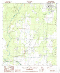
1986 Map of Oberlin
USGS Topo · Published 1987About this map
The parish seat of Oberlin and the surrounding piney woods and bottomlands define this mid-1980s landscape. This document captures the transition from the winding course of the Calcasieu River and Whiskey Creek to the industrial agricultural engineering of the Kinder Canal. To the south, the Coushatta Indian Reservation sits near the rural settlement of Lyles, while to the east, the terrain descends toward Bayou Blue. The map reveals the local infrastructure of the era, from the Lookout Tower near Le Jeune to the small rural landing sites like the Landing Strip. Significant for genealogists and local historians, it documents several small settlements including Elder and Le Jeune, alongside local landmarks such as Fish Ponds and a Sewage Disposal Ponds system, reflecting the development of Allen Parish in the late 20th century.
Find a feature on this map
18 named features on this map. Tap any name to fly to it.
Don’t see what you’re looking for? This feature index may not catch every label — zoom into the map to look around manually.
Map Details
Editions of this 1986 Oberlin Map
This is the sole edition of this map. No revisions or reprints were ever made.
Other maps of this area

1935 · Mittie
USGS Topo · 1:31,680

1947 · Kinder
USGS Topo · 1:31,680

1947 · Foley
USGS Topo · 1:31,680

1947 · Oberlin
USGS Topo · 1:31,680

1947 · Pine Chapel
USGS Topo · 1:31,680

1947 · Le Blanc
USGS Topo · 1:31,680

1947 · Elton
USGS Topo · 1:31,680

1947 · Edna
USGS Topo · 1:31,680
1948 · Mittie
USGS Topo · 1:24,000
1948 · Pine Chapel
USGS Topo · 1:24,000