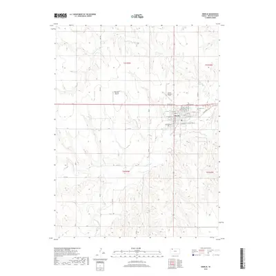
2018 Map of Oberlin
USGS Topo · Published 2018About this map
The Decatur County seat of Oberlin serves as the central hub of this modern Western Kansas landscape, defined by its orderly grid and the winding paths of the Sappa Creek system. The town's layout is clearly delineated by streets such as W Frontier Pkwy and E Commercial St, reflecting a community deeply tied to the surrounding agricultural plains. Beyond the residential core, the Oberlin Cem stands on the eastern edge of town, while local aviation is supported by the Oberlin Municipal Airport and the specialized Shaw Aerial Spraying Airport to the northwest.
Find a feature on this map
45 named features on this map. Tap any name to fly to it.
Don’t see what you’re looking for? This feature index may not catch every label — zoom into the map to look around manually.
Map Details
Editions of this 2018 Oberlin Map
This is the sole edition of this map. No revisions or reprints were ever made.
Other maps of this area

1951 · Selden
USGS Topo · 1:62,500

1951 · Oberlin
USGS Topo · 1:62,500

1951 · Kanona
USGS Topo · 1:62,500

1954 · Goodland
USGS Topo · 1:250,000

1956 · Goodland
USGS Topo · 1:250,000

1957 · Goodland
USGS Topo · 1:250,000

1965 · Oberlin
USGS Topo · 1:24,000

1965 · Kanona
USGS Topo · 1:24,000

1965 · Oberlin SW
USGS Topo · 1:24,000
1965 · Kanona NW
USGS Topo · 1:24,000