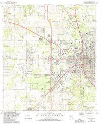
1991 Map of Ocala West
USGS Topo · Published 1991About this map
Ocala's western expansion and institutional development are captured here in detail as the city grew toward the Ocala Municipal Airport Jim Taylor Field. The landscape reflects a mix of civic infrastructure and historic local landmarks, from the Federal Bldg Courthouse and City Hall downtown to the sprawling campus of Central Florida Jr College. The transition from urban density to rural outskirts is marked by numerous churches and cemeteries, including Lincoln Mem Cem and the Mt Tabor Ch area near Kendrick.
Find a feature on this map
69 named features on this map. Tap any name to fly to it.
Don’t see what you’re looking for? This feature index may not catch every label — zoom into the map to look around manually.
Map Details
Editions of this 1991 Ocala West Map
This is the sole edition of this map. No revisions or reprints were ever made.
Other maps of this area

1892 · Dunnellon
USGS Topo · 1:62,500

1893 · Citra
USGS Topo · 1:62,500

1894 · Dunnellon
USGS Topo · 1:62,500

1895 · Williston
USGS Topo · 1:62,500

1895 · Citra
USGS Topo · 1:62,500

1895 · Ocala
USGS Topo · 1:62,500

1954 · Cotton Plant
USGS Topo · 1:24,000

1954 · Dunnellon SE
USGS Topo · 1:24,000

1954 · Dunnellon
USGS Topo · 1:62,500

1954 · Gainesville
USGS Topo · 1:250,000