
1954 Map of Dunnellon
USGS Topo · Published 1960About this map
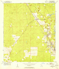
Dunnellon serves as a major rail hub in the mid-1950s, where the Atlantic Coast Line and Seaboard Air Line intersect near the Withlacoochee River. The landscape is a complex patchwork of natural springs and industrial activity, notably the Rainbow Springs Waterfall and the Tailings Ponds south of town. Rural communities such as Cotton Plant, Romeo, and Martel are connected by a network of unimproved roads and light-duty tracks, serving a territory dotted with small prairies and ponds like Sturges Prairie and Dry Cow House Prairie. Local history is preserved in numerous country churches and burial grounds, including the Zion Hill Church and the Rockwell Cem near Chatmar. The presence of several Gravel Pits and mines reflects the area's active extraction economy during this era.
Find a feature on this map
69 named features on this map. Tap any name to fly to it.
Don’t see what you’re looking for? This feature index may not catch every label — zoom into the map to look around manually.
Map Details
Editions of this 1954 Dunnellon Map
This is the sole edition of this map. No revisions or reprints were ever made.
Other maps of this area

1892 · Dunnellon
USGS Topo · 1:62,500

1893 · Panasoffkee
USGS Topo · 1:62,500

1893 · Citra
USGS Topo · 1:62,500

1894 · Dunnellon
USGS Topo · 1:62,500

1895 · Williston
USGS Topo · 1:62,500

1895 · Tsala Apopka
USGS Topo · 1:62,500

1895 · Citra
USGS Topo · 1:62,500

1895 · Panasoffkee
USGS Topo · 1:62,500

1895 · Ocala
USGS Topo · 1:62,500
1954 · Holder
USGS Topo · 1:24,000