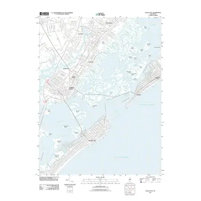
2011 Map of Ocean City
USGS Topo · Published 2011About this map
Ocean City and its neighboring coastal communities define this 2011 survey, showing the intricate relationship between the barrier island resorts and the mainland. The landscape is a complex network of salt marshes and tidal channels, where the Intracoastal Waterway winds through Scull Bay and Peck Bay to reach the Great Egg Harbor Inlet. On the mainland, established settlements like Linwood, Somers Point, and Northfield are separated from the Atlantic by an expansive mosaic of landforms, including Cowpens Island and the Rainbow Islands. The map detail highlights the region's leisure and transport infrastructure, from the iconic Boardwalk and the Ocean City Municipal Airport to the Garden State Parkway corridor. This era's footprint is visible in the dense residential street grids that press against the wetland margins of Bargaintown Pond and Patcong Creek.
Find a feature on this map
48 named features on this map. Tap any name to fly to it.
Don’t see what you’re looking for? This feature index may not catch every label — zoom into the map to look around manually.
Map Details
Editions of this 2011 Ocean City Map
This is the sole edition of this map. No revisions or reprints were ever made.
Other maps of this area

1884 · Sea Isle
USGS Topo · 1:62,500

1887 · Atlantic City
USGS Topo · 1:62,500

1888 · Sea Isle
USGS Topo · 1:62,500

1890 · Great Egg Harbor
USGS Topo · 1:62,500

1893 · Great Egg Harbor
USGS Topo · 1:62,500

1894 · Sea Isle
USGS Topo · 1:62,500

1894 · Atlantic City
USGS Topo · 1:62,500

1918 · Great Egg Harbor
USGS Topo · 1:62,500

1919 · Sea Isle
USGS Topo · 1:62,500

1940 · Atlantic City
USGS Topo · 1:62,500