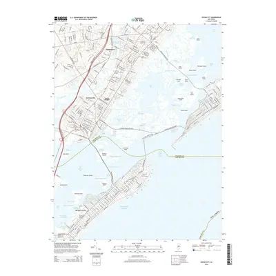
2014 Map of Ocean City
USGS Topo · Published 2014About this map
Ocean City occupies the southern barrier island in this coastal survey, where the grid of Boardwalk, Asbury Ave, and Wesley Ave defines the early 21st-century resort layout. The complex aquatic landscape of Great Egg Harbor Bay is dissected by numerous channels and thoroughfares, including Broad Thorofare and the Stanton Memorial Cswy, which links the island to the mainland. On the Atlantic County side, inland settlements like Bargaintown and Steelmanville are situated near Bargaintown Pond and the Garden State Pky corridor. Local landmarks such as the Ocean City Municipal Airport and Friends Central Cem are documented alongside the intricate network of tidal islands, including Cowpens Island and Drag Island, illustrating the intersection of suburban development and the sensitive marshland environment of the New Jersey shore.
Find a feature on this map
93 named features on this map. Tap any name to fly to it.
Don’t see what you’re looking for? This feature index may not catch every label — zoom into the map to look around manually.
Map Details
Editions of this 2014 Ocean City Map
This is the sole edition of this map. No revisions or reprints were ever made.
Other maps of this area

1884 · Sea Isle
USGS Topo · 1:62,500

1887 · Atlantic City
USGS Topo · 1:62,500

1888 · Sea Isle
USGS Topo · 1:62,500

1890 · Great Egg Harbor
USGS Topo · 1:62,500

1893 · Great Egg Harbor
USGS Topo · 1:62,500

1894 · Sea Isle
USGS Topo · 1:62,500

1894 · Atlantic City
USGS Topo · 1:62,500

1918 · Great Egg Harbor
USGS Topo · 1:62,500

1919 · Sea Isle
USGS Topo · 1:62,500

1940 · Atlantic City
USGS Topo · 1:62,500